You are here: Home > Network List > TA - USArray Transportable Network (new EarthScope stations) Stations List
> Station MSTX Muleshoe, TX, USA > Earthquake Result Viewer
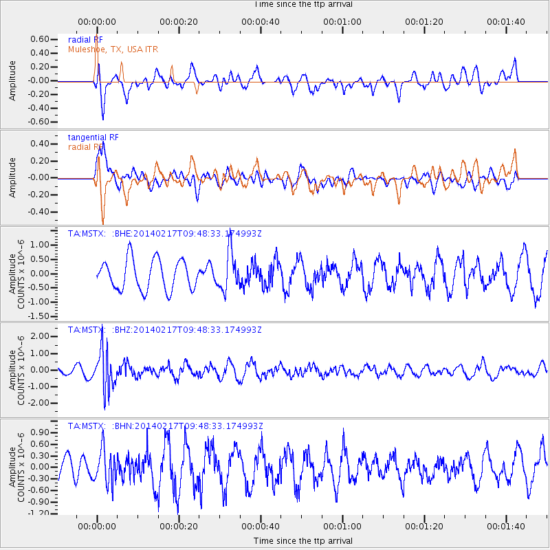
MSTX Muleshoe, TX, USA - Earthquake Result Viewer
*The percent match for this event was below the threshold and hence no stack was calculated.
| Earthquake location: |
Northern Colombia |
| Earthquake latitude/longitude: |
6.5/-71.7 |
| Earthquake time(UTC): |
2014/02/17 (048) 09:41:35 GMT |
| Earthquake Depth: |
41 km |
| Earthquake Magnitude: |
5.3 MW |
| Earthquake Catalog/Contributor: |
ISC/ISC |
|
| Network: |
TA USArray Transportable Network (new EarthScope stations) |
| Station: |
MSTX Muleshoe, TX, USA |
| Lat/Lon: |
33.97 N/102.77 W |
| Elevation: |
1167 m |
|
| Distance: |
39.6 deg |
| Az: |
317.748 deg |
| Baz: |
126.498 deg |
| Ray Param: |
$rayparam |
*The percent match for this event was below the threshold and hence was not used in the summary stack. |
|
| Radial Match: |
57.87688 % |
| Radial Bump: |
400 |
| Transverse Match: |
69.13247 % |
| Transverse Bump: |
400 |
| SOD ConfigId: |
3390531 |
| Insert Time: |
2019-04-10 08:55:16.954 +0000 |
| GWidth: |
2.5 |
| Max Bumps: |
400 |
| Tol: |
0.001 |
|
Signal To Noise
| Channel | StoN | STA | LTA |
| TA:MSTX: :BHZ:20140217T09:48:33.174993Z | 3.8869662 | 1.1777846E-6 | 3.030087E-7 |
| TA:MSTX: :BHN:20140217T09:48:33.174993Z | 1.1328359 | 4.4228722E-7 | 3.9042482E-7 |
| TA:MSTX: :BHE:20140217T09:48:33.174993Z | 1.3243154 | 6.9370424E-7 | 5.23821E-7 |
| Arrivals |
| Ps | |
| PpPs | |
| PsPs/PpSs | |


