You are here: Home > Network List > UW - Pacific Northwest Regional Seismic Network Stations List
> Station YACT Amboy, WA, USA > Earthquake Result Viewer
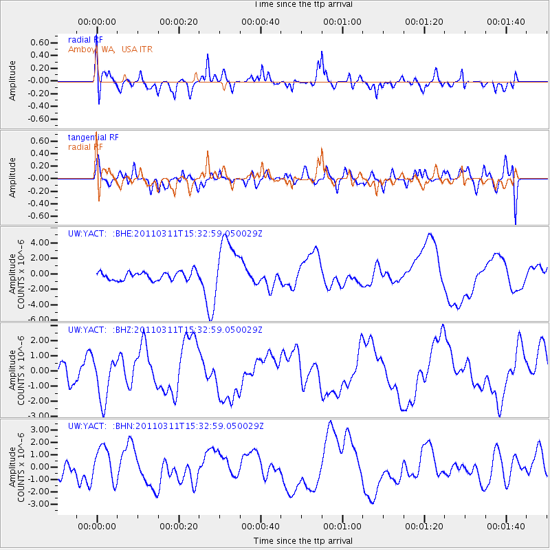
YACT Amboy, WA, USA - Earthquake Result Viewer
*The percent match for this event was below the threshold and hence no stack was calculated.
| Earthquake location: |
Near East Coast Of Honshu, Japan |
| Earthquake latitude/longitude: |
35.6/141.5 |
| Earthquake time(UTC): |
2011/03/11 (070) 15:22:27 GMT |
| Earthquake Depth: |
35 km |
| Earthquake Magnitude: |
5.5 MB |
| Earthquake Catalog/Contributor: |
WHDF/NEIC |
|
| Network: |
UW Pacific Northwest Regional Seismic Network |
| Station: |
YACT Amboy, WA, USA |
| Lat/Lon: |
45.93 N/122.42 W |
| Elevation: |
211 m |
|
| Distance: |
69.2 deg |
| Az: |
47.954 deg |
| Baz: |
299.918 deg |
| Ray Param: |
$rayparam |
*The percent match for this event was below the threshold and hence was not used in the summary stack. |
|
| Radial Match: |
39.261932 % |
| Radial Bump: |
394 |
| Transverse Match: |
52.608307 % |
| Transverse Bump: |
400 |
| SOD ConfigId: |
356183 |
| Insert Time: |
2011-08-17 10:35:38.153 +0000 |
| GWidth: |
2.5 |
| Max Bumps: |
400 |
| Tol: |
0.001 |
|
Signal To Noise
| Channel | StoN | STA | LTA |
| UW:YACT: :BHZ:20110311T15:32:59.050029Z | 2.2791123 | 1.4233276E-6 | 6.245097E-7 |
| UW:YACT: :BHN:20110311T15:32:59.050029Z | 2.6195498 | 1.3693535E-6 | 5.2274385E-7 |
| UW:YACT: :BHE:20110311T15:32:59.050029Z | 6.9113097 | 3.6717433E-6 | 5.312659E-7 |
| Arrivals |
| Ps | |
| PpPs | |
| PsPs/PpSs | |


