You are here: Home > Network List > UW - Pacific Northwest Regional Seismic Network Stations List
> Station HOOD Mt Hood Meadows, OR CREST BB SMO > Earthquake Result Viewer
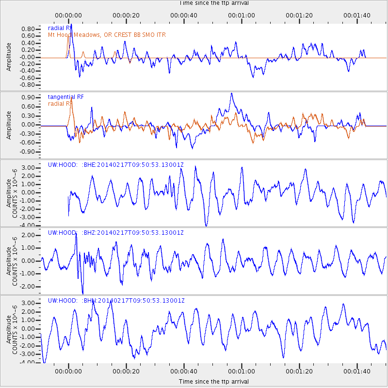
HOOD Mt Hood Meadows, OR CREST BB SMO - Earthquake Result Viewer
*The percent match for this event was below the threshold and hence no stack was calculated.
| Earthquake location: |
Northern Colombia |
| Earthquake latitude/longitude: |
6.5/-71.7 |
| Earthquake time(UTC): |
2014/02/17 (048) 09:41:35 GMT |
| Earthquake Depth: |
41 km |
| Earthquake Magnitude: |
5.3 MW |
| Earthquake Catalog/Contributor: |
ISC/ISC |
|
| Network: |
UW Pacific Northwest Regional Seismic Network |
| Station: |
HOOD Mt Hood Meadows, OR CREST BB SMO |
| Lat/Lon: |
45.32 N/121.65 W |
| Elevation: |
1520 m |
|
| Distance: |
57.9 deg |
| Az: |
320.401 deg |
| Baz: |
116.145 deg |
| Ray Param: |
$rayparam |
*The percent match for this event was below the threshold and hence was not used in the summary stack. |
|
| Radial Match: |
54.495094 % |
| Radial Bump: |
400 |
| Transverse Match: |
38.833828 % |
| Transverse Bump: |
400 |
| SOD ConfigId: |
3390531 |
| Insert Time: |
2019-04-10 08:56:25.301 +0000 |
| GWidth: |
2.5 |
| Max Bumps: |
400 |
| Tol: |
0.001 |
|
Signal To Noise
| Channel | StoN | STA | LTA |
| UW:HOOD: :BHZ:20140217T09:50:53.13001Z | 1.1985698 | 9.655024E-7 | 8.055455E-7 |
| UW:HOOD: :BHN:20140217T09:50:53.13001Z | 0.8464053 | 1.605238E-6 | 1.8965359E-6 |
| UW:HOOD: :BHE:20140217T09:50:53.13001Z | 0.75318605 | 7.9009675E-7 | 1.0490061E-6 |
| Arrivals |
| Ps | |
| PpPs | |
| PsPs/PpSs | |


