You are here: Home > Network List > TA - USArray Transportable Network (new EarthScope stations) Stations List
> Station P33A Williams Farm, Concordia, KS, USA > Earthquake Result Viewer
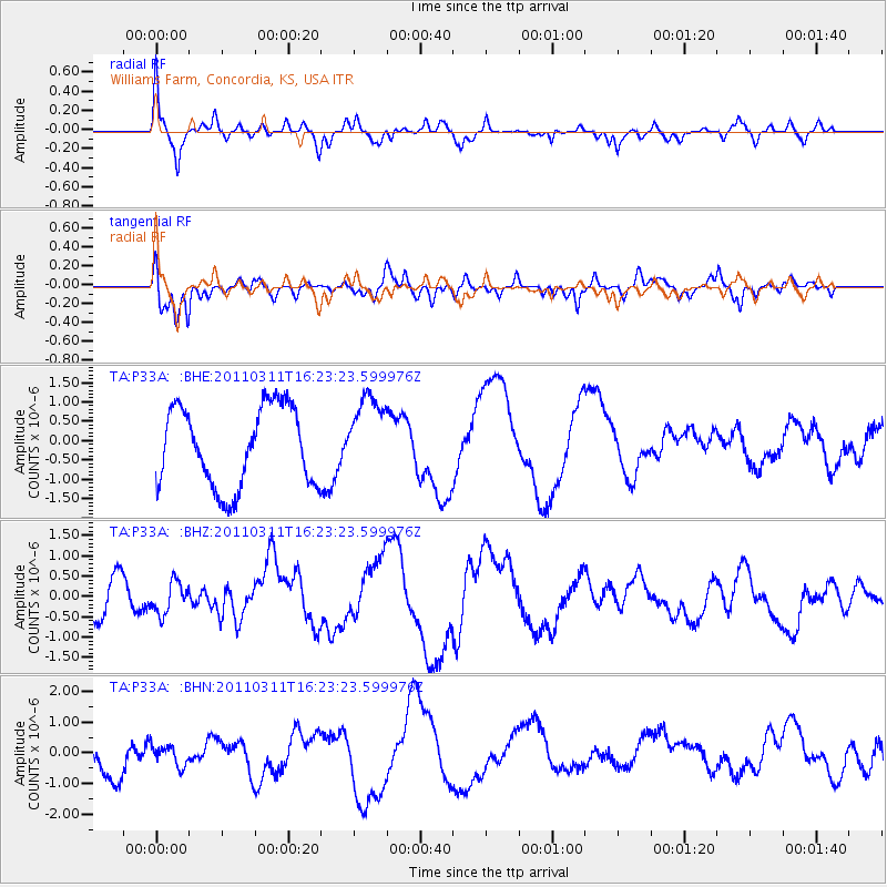
P33A Williams Farm, Concordia, KS, USA - Earthquake Result Viewer
*The percent match for this event was below the threshold and hence no stack was calculated.
| Earthquake location: |
Off East Coast Of Honshu, Japan |
| Earthquake latitude/longitude: |
39.5/143.5 |
| Earthquake time(UTC): |
2011/03/11 (070) 16:11:30 GMT |
| Earthquake Depth: |
35 km |
| Earthquake Magnitude: |
5.5 MB |
| Earthquake Catalog/Contributor: |
WHDF/NEIC |
|
| Network: |
TA USArray Transportable Network (new EarthScope stations) |
| Station: |
P33A Williams Farm, Concordia, KS, USA |
| Lat/Lon: |
39.44 N/97.69 W |
| Elevation: |
488 m |
|
| Distance: |
83.6 deg |
| Az: |
43.048 deg |
| Baz: |
316.973 deg |
| Ray Param: |
$rayparam |
*The percent match for this event was below the threshold and hence was not used in the summary stack. |
|
| Radial Match: |
43.326855 % |
| Radial Bump: |
374 |
| Transverse Match: |
66.01257 % |
| Transverse Bump: |
400 |
| SOD ConfigId: |
356183 |
| Insert Time: |
2011-08-17 12:15:14.257 +0000 |
| GWidth: |
2.5 |
| Max Bumps: |
400 |
| Tol: |
0.001 |
|
Signal To Noise
| Channel | StoN | STA | LTA |
| TA:P33A: :BHZ:20110311T16:23:23.599976Z | 0.4770502 | 3.971083E-7 | 8.324245E-7 |
| TA:P33A: :BHN:20110311T16:23:23.599976Z | 0.33558404 | 3.4881808E-7 | 1.0394358E-6 |
| TA:P33A: :BHE:20110311T16:23:23.599976Z | 1.0188816 | 1.0432223E-6 | 1.0238897E-6 |
| Arrivals |
| Ps | |
| PpPs | |
| PsPs/PpSs | |


