You are here: Home > Network List > TA - USArray Transportable Network (new EarthScope stations) Stations List
> Station W33A Caddo, Fort Cobb, OK, USA > Earthquake Result Viewer
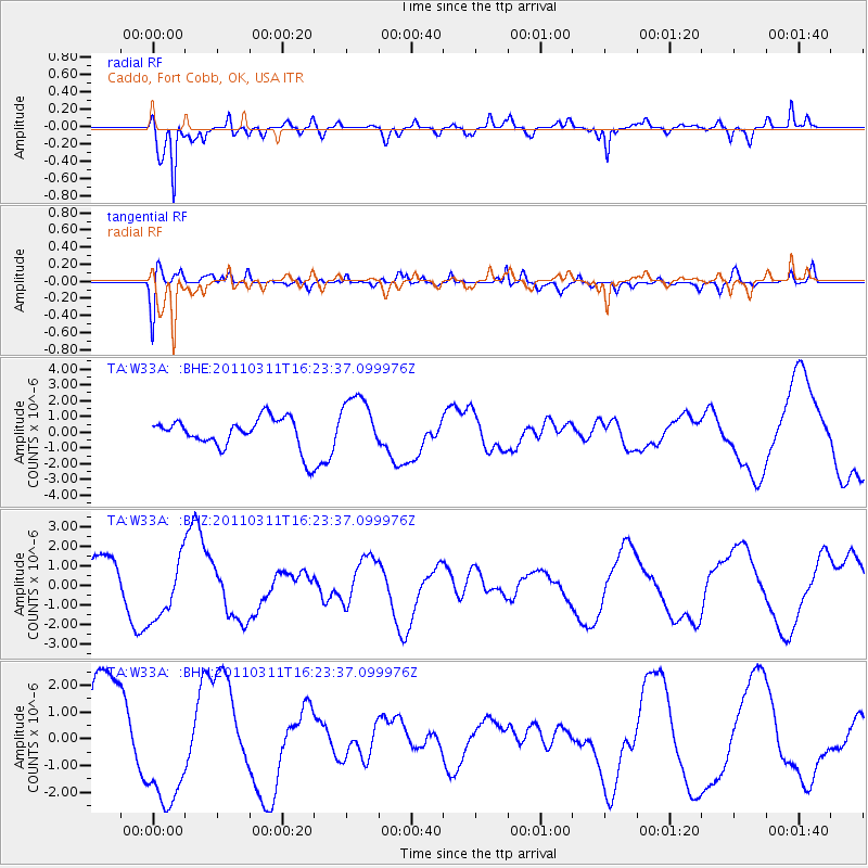
W33A Caddo, Fort Cobb, OK, USA - Earthquake Result Viewer
*The percent match for this event was below the threshold and hence no stack was calculated.
| Earthquake location: |
Off East Coast Of Honshu, Japan |
| Earthquake latitude/longitude: |
39.5/143.5 |
| Earthquake time(UTC): |
2011/03/11 (070) 16:11:30 GMT |
| Earthquake Depth: |
35 km |
| Earthquake Magnitude: |
5.5 MB |
| Earthquake Catalog/Contributor: |
WHDF/NEIC |
|
| Network: |
TA USArray Transportable Network (new EarthScope stations) |
| Station: |
W33A Caddo, Fort Cobb, OK, USA |
| Lat/Lon: |
35.15 N/98.47 W |
| Elevation: |
414 m |
|
| Distance: |
86.3 deg |
| Az: |
46.434 deg |
| Baz: |
316.804 deg |
| Ray Param: |
$rayparam |
*The percent match for this event was below the threshold and hence was not used in the summary stack. |
|
| Radial Match: |
87.92746 % |
| Radial Bump: |
348 |
| Transverse Match: |
39.524166 % |
| Transverse Bump: |
400 |
| SOD ConfigId: |
356183 |
| Insert Time: |
2011-08-17 12:17:45.872 +0000 |
| GWidth: |
2.5 |
| Max Bumps: |
400 |
| Tol: |
0.001 |
|
Signal To Noise
| Channel | StoN | STA | LTA |
| TA:W33A: :BHZ:20110311T16:23:37.099976Z | 1.8392017 | 1.6404917E-6 | 8.919586E-7 |
| TA:W33A: :BHN:20110311T16:23:37.099976Z | 1.3645086 | 2.3537716E-6 | 1.7249957E-6 |
| TA:W33A: :BHE:20110311T16:23:37.099976Z | 1.8878886 | 1.8033888E-6 | 9.552411E-7 |
| Arrivals |
| Ps | |
| PpPs | |
| PsPs/PpSs | |


