You are here: Home > Network List > TA - USArray Transportable Network (new EarthScope stations) Stations List
> Station 434A Burnet, TX, USA > Earthquake Result Viewer
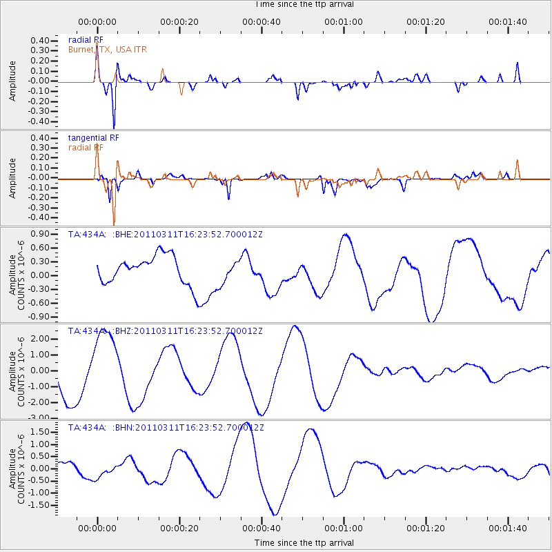
434A Burnet, TX, USA - Earthquake Result Viewer
*The percent match for this event was below the threshold and hence no stack was calculated.
| Earthquake location: |
Off East Coast Of Honshu, Japan |
| Earthquake latitude/longitude: |
39.5/143.5 |
| Earthquake time(UTC): |
2011/03/11 (070) 16:11:30 GMT |
| Earthquake Depth: |
35 km |
| Earthquake Magnitude: |
5.5 MB |
| Earthquake Catalog/Contributor: |
WHDF/NEIC |
|
| Network: |
TA USArray Transportable Network (new EarthScope stations) |
| Station: |
434A Burnet, TX, USA |
| Lat/Lon: |
30.81 N/98.27 W |
| Elevation: |
462 m |
|
| Distance: |
89.6 deg |
| Az: |
49.268 deg |
| Baz: |
317.014 deg |
| Ray Param: |
$rayparam |
*The percent match for this event was below the threshold and hence was not used in the summary stack. |
|
| Radial Match: |
69.61724 % |
| Radial Bump: |
400 |
| Transverse Match: |
75.290054 % |
| Transverse Bump: |
400 |
| SOD ConfigId: |
356183 |
| Insert Time: |
2011-08-17 12:20:02.721 +0000 |
| GWidth: |
2.5 |
| Max Bumps: |
400 |
| Tol: |
0.001 |
|
Signal To Noise
| Channel | StoN | STA | LTA |
| TA:434A: :BHZ:20110311T16:23:52.700012Z | 1.8613886 | 2.3001774E-6 | 1.2357319E-6 |
| TA:434A: :BHN:20110311T16:23:52.700012Z | 1.4523798 | 2.996217E-7 | 2.0629706E-7 |
| TA:434A: :BHE:20110311T16:23:52.700012Z | 0.82335174 | 2.564541E-7 | 3.1147573E-7 |
| Arrivals |
| Ps | |
| PpPs | |
| PsPs/PpSs | |


