You are here: Home > Network List > TA - USArray Transportable Network (new EarthScope stations) Stations List
> Station N35A Tabor, IA, USA > Earthquake Result Viewer
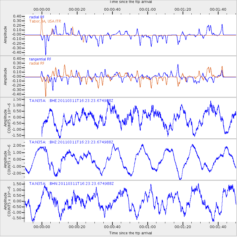
N35A Tabor, IA, USA - Earthquake Result Viewer
*The percent match for this event was below the threshold and hence no stack was calculated.
| Earthquake location: |
Off East Coast Of Honshu, Japan |
| Earthquake latitude/longitude: |
39.5/143.5 |
| Earthquake time(UTC): |
2011/03/11 (070) 16:11:30 GMT |
| Earthquake Depth: |
35 km |
| Earthquake Magnitude: |
5.5 MB |
| Earthquake Catalog/Contributor: |
WHDF/NEIC |
|
| Network: |
TA USArray Transportable Network (new EarthScope stations) |
| Station: |
N35A Tabor, IA, USA |
| Lat/Lon: |
40.86 N/95.64 W |
| Elevation: |
353 m |
|
| Distance: |
83.6 deg |
| Az: |
40.914 deg |
| Baz: |
318.054 deg |
| Ray Param: |
$rayparam |
*The percent match for this event was below the threshold and hence was not used in the summary stack. |
|
| Radial Match: |
86.325455 % |
| Radial Bump: |
400 |
| Transverse Match: |
66.68108 % |
| Transverse Bump: |
400 |
| SOD ConfigId: |
356183 |
| Insert Time: |
2011-08-17 12:27:09.934 +0000 |
| GWidth: |
2.5 |
| Max Bumps: |
400 |
| Tol: |
0.001 |
|
Signal To Noise
| Channel | StoN | STA | LTA |
| TA:N35A: :BHZ:20110311T16:23:23.674988Z | 1.9090278 | 1.6466608E-6 | 8.625652E-7 |
| TA:N35A: :BHN:20110311T16:23:23.674988Z | 1.3876759 | 8.117552E-7 | 5.8497466E-7 |
| TA:N35A: :BHE:20110311T16:23:23.674988Z | 0.5584091 | 3.2513555E-7 | 5.8225334E-7 |
| Arrivals |
| Ps | |
| PpPs | |
| PsPs/PpSs | |


