You are here: Home > Network List > TA - USArray Transportable Network (new EarthScope stations) Stations List
> Station A33A Warroad, MN, USA > Earthquake Result Viewer
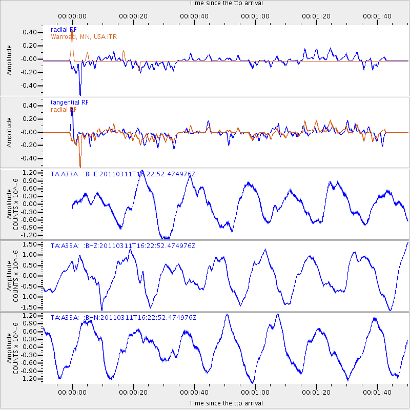
A33A Warroad, MN, USA - Earthquake Result Viewer
*The percent match for this event was below the threshold and hence no stack was calculated.
| Earthquake location: |
Off East Coast Of Honshu, Japan |
| Earthquake latitude/longitude: |
39.5/143.5 |
| Earthquake time(UTC): |
2011/03/11 (070) 16:11:30 GMT |
| Earthquake Depth: |
35 km |
| Earthquake Magnitude: |
5.5 MB |
| Earthquake Catalog/Contributor: |
WHDF/NEIC |
|
| Network: |
TA USArray Transportable Network (new EarthScope stations) |
| Station: |
A33A Warroad, MN, USA |
| Lat/Lon: |
48.94 N/95.39 W |
| Elevation: |
329 m |
|
| Distance: |
77.8 deg |
| Az: |
35.273 deg |
| Baz: |
317.318 deg |
| Ray Param: |
$rayparam |
*The percent match for this event was below the threshold and hence was not used in the summary stack. |
|
| Radial Match: |
78.79927 % |
| Radial Bump: |
381 |
| Transverse Match: |
71.660515 % |
| Transverse Bump: |
400 |
| SOD ConfigId: |
356183 |
| Insert Time: |
2011-08-17 12:37:58.543 +0000 |
| GWidth: |
2.5 |
| Max Bumps: |
400 |
| Tol: |
0.001 |
|
Signal To Noise
| Channel | StoN | STA | LTA |
| TA:A33A: :BHZ:20110311T16:22:52.474976Z | 1.191031 | 7.888639E-7 | 6.62337E-7 |
| TA:A33A: :BHN:20110311T16:22:52.474976Z | 1.2753531 | 7.429644E-7 | 5.8255586E-7 |
| TA:A33A: :BHE:20110311T16:22:52.474976Z | 2.2985756 | 1.1624267E-6 | 5.057161E-7 |
| Arrivals |
| Ps | |
| PpPs | |
| PsPs/PpSs | |


