You are here: Home > Network List > US - United States National Seismic Network Stations List
> Station HLID Hailey, Idaho, USA > Earthquake Result Viewer
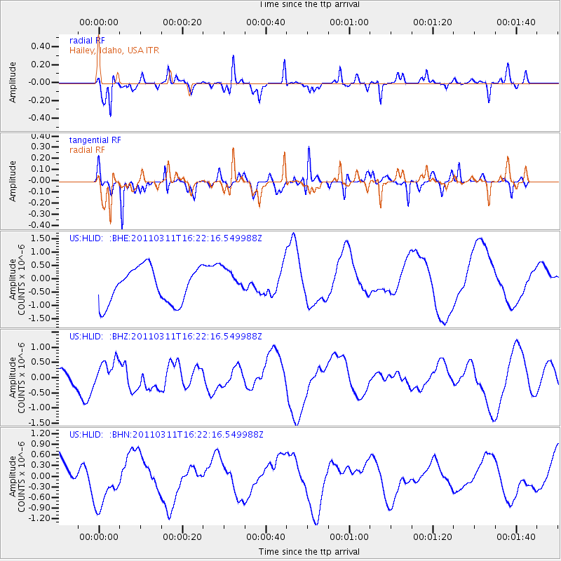
HLID Hailey, Idaho, USA - Earthquake Result Viewer
*The percent match for this event was below the threshold and hence no stack was calculated.
| Earthquake location: |
Off East Coast Of Honshu, Japan |
| Earthquake latitude/longitude: |
39.5/143.5 |
| Earthquake time(UTC): |
2011/03/11 (070) 16:11:30 GMT |
| Earthquake Depth: |
35 km |
| Earthquake Magnitude: |
5.5 MB |
| Earthquake Catalog/Contributor: |
WHDF/NEIC |
|
| Network: |
US United States National Seismic Network |
| Station: |
HLID Hailey, Idaho, USA |
| Lat/Lon: |
43.56 N/114.41 W |
| Elevation: |
1772 m |
|
| Distance: |
71.5 deg |
| Az: |
48.526 deg |
| Baz: |
307.071 deg |
| Ray Param: |
$rayparam |
*The percent match for this event was below the threshold and hence was not used in the summary stack. |
|
| Radial Match: |
49.353004 % |
| Radial Bump: |
317 |
| Transverse Match: |
66.602875 % |
| Transverse Bump: |
325 |
| SOD ConfigId: |
356183 |
| Insert Time: |
2011-08-17 12:50:37.907 +0000 |
| GWidth: |
2.5 |
| Max Bumps: |
400 |
| Tol: |
0.001 |
|
Signal To Noise
| Channel | StoN | STA | LTA |
| US:HLID: :BHZ:20110311T16:22:16.549988Z | 0.652135 | 5.1321615E-7 | 7.869783E-7 |
| US:HLID: :BHN:20110311T16:22:16.549988Z | 1.4763011 | 7.1530735E-7 | 4.845267E-7 |
| US:HLID: :BHE:20110311T16:22:16.549988Z | 0.7617958 | 4.989667E-7 | 6.5498745E-7 |
| Arrivals |
| Ps | |
| PpPs | |
| PsPs/PpSs | |


