You are here: Home > Network List > GS - US Geological Survey Networks Stations List
> Station DEC12 Boyd Road Surface Site > Earthquake Result Viewer
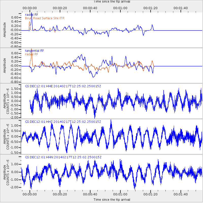
DEC12 Boyd Road Surface Site - Earthquake Result Viewer
*The percent match for this event was below the threshold and hence no stack was calculated.
| Earthquake location: |
Tonga Islands |
| Earthquake latitude/longitude: |
-17.8/-173.0 |
| Earthquake time(UTC): |
2014/02/17 (048) 12:12:05 GMT |
| Earthquake Depth: |
26 km |
| Earthquake Magnitude: |
5.0 MW |
| Earthquake Catalog/Contributor: |
ISC/ISC |
|
| Network: |
GS US Geological Survey Networks |
| Station: |
DEC12 Boyd Road Surface Site |
| Lat/Lon: |
39.91 N/88.91 W |
| Elevation: |
208 m |
|
| Distance: |
96.9 deg |
| Az: |
50.421 deg |
| Baz: |
252.628 deg |
| Ray Param: |
$rayparam |
*The percent match for this event was below the threshold and hence was not used in the summary stack. |
|
| Radial Match: |
67.341156 % |
| Radial Bump: |
400 |
| Transverse Match: |
52.53003 % |
| Transverse Bump: |
400 |
| SOD ConfigId: |
3390531 |
| Insert Time: |
2019-04-10 08:59:18.393 +0000 |
| GWidth: |
2.5 |
| Max Bumps: |
400 |
| Tol: |
0.001 |
|
Signal To Noise
| Channel | StoN | STA | LTA |
| GS:DEC12:01:HHZ:20140217T12:25:02.250015Z | 0.4390897 | 2.0709635E-7 | 4.716493E-7 |
| GS:DEC12:01:HHN:20140217T12:25:02.250015Z | 3.0012214 | 1.204676E-6 | 4.0139523E-7 |
| GS:DEC12:01:HHE:20140217T12:25:02.250015Z | 0.72121096 | 4.0377998E-7 | 5.5986385E-7 |
| Arrivals |
| Ps | |
| PpPs | |
| PsPs/PpSs | |


