You are here: Home > Network List > IU - Global Seismograph Network (GSN - IRIS/USGS) Stations List
> Station RSSD Black Hills, South Dakota, USA > Earthquake Result Viewer
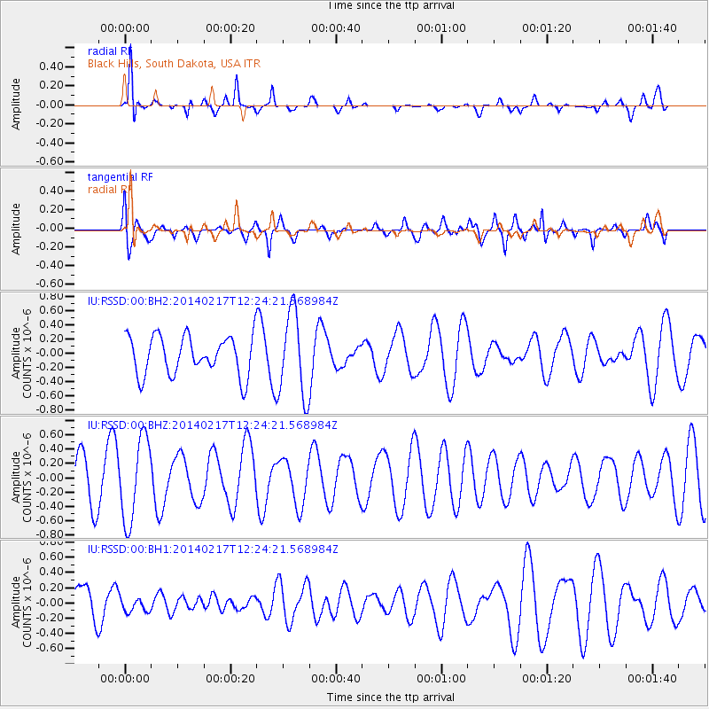
RSSD Black Hills, South Dakota, USA - Earthquake Result Viewer
*The percent match for this event was below the threshold and hence no stack was calculated.
| Earthquake location: |
Tonga Islands |
| Earthquake latitude/longitude: |
-17.8/-173.0 |
| Earthquake time(UTC): |
2014/02/17 (048) 12:12:05 GMT |
| Earthquake Depth: |
26 km |
| Earthquake Magnitude: |
5.0 MW |
| Earthquake Catalog/Contributor: |
ISC/ISC |
|
| Network: |
IU Global Seismograph Network (GSN - IRIS/USGS) |
| Station: |
RSSD Black Hills, South Dakota, USA |
| Lat/Lon: |
44.12 N/104.04 W |
| Elevation: |
2090 m |
|
| Distance: |
88.0 deg |
| Az: |
42.285 deg |
| Baz: |
242.851 deg |
| Ray Param: |
$rayparam |
*The percent match for this event was below the threshold and hence was not used in the summary stack. |
|
| Radial Match: |
75.354515 % |
| Radial Bump: |
297 |
| Transverse Match: |
56.749607 % |
| Transverse Bump: |
400 |
| SOD ConfigId: |
3390531 |
| Insert Time: |
2019-04-10 08:59:33.381 +0000 |
| GWidth: |
2.5 |
| Max Bumps: |
400 |
| Tol: |
0.001 |
|
Signal To Noise
| Channel | StoN | STA | LTA |
| IU:RSSD:00:BHZ:20140217T12:24:21.568984Z | 1.419226 | 5.813458E-7 | 4.096217E-7 |
| IU:RSSD:00:BH1:20140217T12:24:21.568984Z | 0.33267173 | 9.8180244E-8 | 2.951265E-7 |
| IU:RSSD:00:BH2:20140217T12:24:21.568984Z | 2.1710882 | 5.9541804E-7 | 2.7424866E-7 |
| Arrivals |
| Ps | |
| PpPs | |
| PsPs/PpSs | |


