You are here: Home > Network List > UW - Pacific Northwest Regional Seismic Network Stations List
> Station HOOD Mt Hood Meadows, OR CREST BB SMO > Earthquake Result Viewer
HOOD Mt Hood Meadows, OR CREST BB SMO - Earthquake Result Viewer
*The percent match for this event was below the threshold and hence no stack was calculated.
| Earthquake location: |
Tonga Islands |
| Earthquake latitude/longitude: |
-17.8/-173.0 |
| Earthquake time(UTC): |
2014/02/17 (048) 12:12:05 GMT |
| Earthquake Depth: |
26 km |
| Earthquake Magnitude: |
5.0 MW |
| Earthquake Catalog/Contributor: |
ISC/ISC |
|
| Network: |
UW Pacific Northwest Regional Seismic Network |
| Station: |
HOOD Mt Hood Meadows, OR CREST BB SMO |
| Lat/Lon: |
45.32 N/121.65 W |
| Elevation: |
1520 m |
|
| Distance: |
78.3 deg |
| Az: |
34.272 deg |
| Baz: |
229.485 deg |
| Ray Param: |
$rayparam |
*The percent match for this event was below the threshold and hence was not used in the summary stack. |
|
| Radial Match: |
37.043633 % |
| Radial Bump: |
400 |
| Transverse Match: |
38.607113 % |
| Transverse Bump: |
400 |
| SOD ConfigId: |
3390531 |
| Insert Time: |
2019-04-10 09:01:27.861 +0000 |
| GWidth: |
2.5 |
| Max Bumps: |
400 |
| Tol: |
0.001 |
|
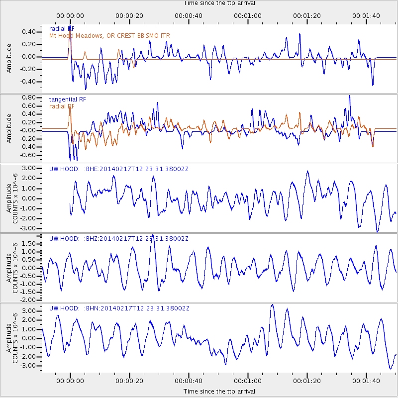
Signal To Noise
| Channel | StoN | STA | LTA |
| UW:HOOD: :BHZ:20140217T12:23:31.38002Z | 0.62116677 | 5.224137E-7 | 8.4102004E-7 |
| UW:HOOD: :BHN:20140217T12:23:31.38002Z | 1.9429982 | 1.9424313E-6 | 9.997083E-7 |
| UW:HOOD: :BHE:20140217T12:23:31.38002Z | 1.5835619 | 1.3233685E-6 | 8.35691E-7 |
| Arrivals |
| Ps | |
| PpPs | |
| PsPs/PpSs | |


