You are here: Home > Network List > TA - USArray Transportable Network (new EarthScope stations) Stations List
> Station R29A Marienthal, KS, USA > Earthquake Result Viewer
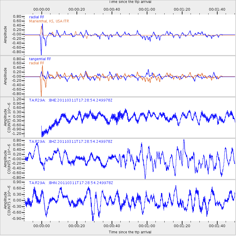
R29A Marienthal, KS, USA - Earthquake Result Viewer
*The percent match for this event was below the threshold and hence no stack was calculated.
| Earthquake location: |
Off East Coast Of Honshu, Japan |
| Earthquake latitude/longitude: |
37.0/144.2 |
| Earthquake time(UTC): |
2011/03/11 (070) 17:16:56 GMT |
| Earthquake Depth: |
9.3 km |
| Earthquake Magnitude: |
5.5 MB, 5.6 MS |
| Earthquake Catalog/Contributor: |
WHDF/NEIC |
|
| Network: |
TA USArray Transportable Network (new EarthScope stations) |
| Station: |
R29A Marienthal, KS, USA |
| Lat/Lon: |
38.42 N/101.14 W |
| Elevation: |
957 m |
|
| Distance: |
83.8 deg |
| Az: |
45.872 deg |
| Baz: |
312.979 deg |
| Ray Param: |
$rayparam |
*The percent match for this event was below the threshold and hence was not used in the summary stack. |
|
| Radial Match: |
51.007336 % |
| Radial Bump: |
400 |
| Transverse Match: |
46.388428 % |
| Transverse Bump: |
356 |
| SOD ConfigId: |
356183 |
| Insert Time: |
2011-08-17 14:08:57.995 +0000 |
| GWidth: |
2.5 |
| Max Bumps: |
400 |
| Tol: |
0.001 |
|
Signal To Noise
| Channel | StoN | STA | LTA |
| TA:R29A: :BHZ:20110311T17:28:54.249978Z | 0.5728203 | 2.0954445E-7 | 3.6581187E-7 |
| TA:R29A: :BHN:20110311T17:28:54.249978Z | 2.0082471 | 3.814421E-7 | 1.8993784E-7 |
| TA:R29A: :BHE:20110311T17:28:54.249978Z | 1.0538725 | 4.5588203E-7 | 4.3257802E-7 |
| Arrivals |
| Ps | |
| PpPs | |
| PsPs/PpSs | |


