You are here: Home > Network List > IC - New China Digital Seismograph Network Stations List
> Station KMI Kunming, Yunnan Province, China > Earthquake Result Viewer
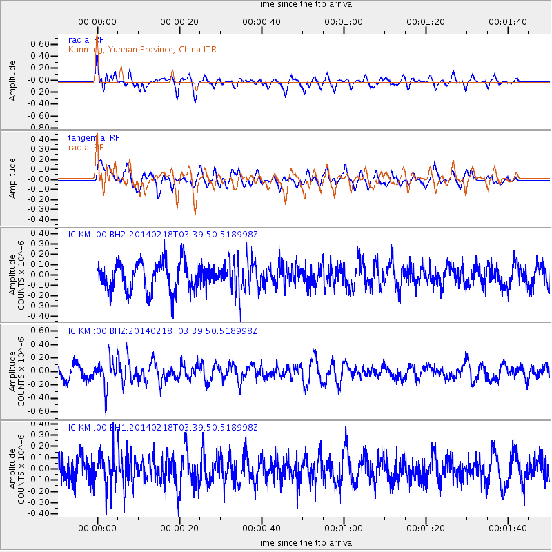
KMI Kunming, Yunnan Province, China - Earthquake Result Viewer
*The percent match for this event was below the threshold and hence no stack was calculated.
| Earthquake location: |
Minahassa Peninsula, Sulawesi |
| Earthquake latitude/longitude: |
1.7/122.9 |
| Earthquake time(UTC): |
2014/02/18 (049) 03:34:12 GMT |
| Earthquake Depth: |
46 km |
| Earthquake Magnitude: |
5.3 MW |
| Earthquake Catalog/Contributor: |
ISC/ISC |
|
| Network: |
IC New China Digital Seismograph Network |
| Station: |
KMI Kunming, Yunnan Province, China |
| Lat/Lon: |
25.12 N/102.74 E |
| Elevation: |
1975 m |
|
| Distance: |
30.4 deg |
| Az: |
321.774 deg |
| Baz: |
136.975 deg |
| Ray Param: |
$rayparam |
*The percent match for this event was below the threshold and hence was not used in the summary stack. |
|
| Radial Match: |
60.89827 % |
| Radial Bump: |
400 |
| Transverse Match: |
44.72433 % |
| Transverse Bump: |
400 |
| SOD ConfigId: |
3390531 |
| Insert Time: |
2019-04-10 09:03:16.551 +0000 |
| GWidth: |
2.5 |
| Max Bumps: |
400 |
| Tol: |
0.001 |
|
Signal To Noise
| Channel | StoN | STA | LTA |
| IC:KMI:00:BHZ:20140218T03:39:50.518998Z | 1.9630288 | 2.2117672E-7 | 1.1267115E-7 |
| IC:KMI:00:BH1:20140218T03:39:50.518998Z | 1.1219571 | 1.4702806E-7 | 1.3104606E-7 |
| IC:KMI:00:BH2:20140218T03:39:50.518998Z | 0.91610926 | 1.3053304E-7 | 1.4248631E-7 |
| Arrivals |
| Ps | |
| PpPs | |
| PsPs/PpSs | |


