You are here: Home > Network List > TA - USArray Transportable Network (new EarthScope stations) Stations List
> Station 239A Gary, TX, USA > Earthquake Result Viewer
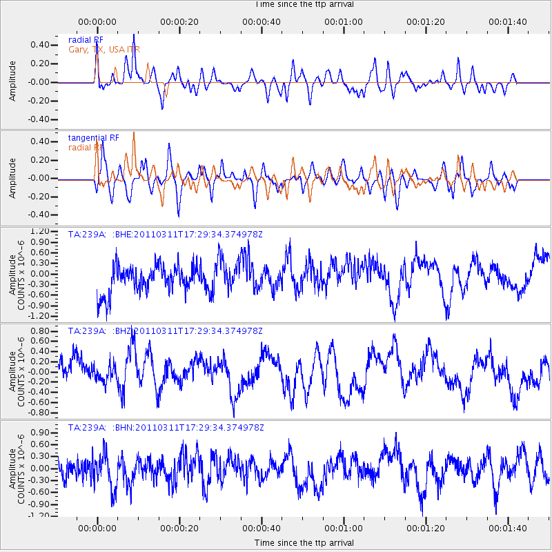
239A Gary, TX, USA - Earthquake Result Viewer
*The percent match for this event was below the threshold and hence no stack was calculated.
| Earthquake location: |
Off East Coast Of Honshu, Japan |
| Earthquake latitude/longitude: |
37.0/144.2 |
| Earthquake time(UTC): |
2011/03/11 (070) 17:16:56 GMT |
| Earthquake Depth: |
9.3 km |
| Earthquake Magnitude: |
5.5 MB, 5.6 MS |
| Earthquake Catalog/Contributor: |
WHDF/NEIC |
|
| Network: |
TA USArray Transportable Network (new EarthScope stations) |
| Station: |
239A Gary, TX, USA |
| Lat/Lon: |
32.02 N/94.47 W |
| Elevation: |
100 m |
|
| Distance: |
92.2 deg |
| Az: |
46.537 deg |
| Baz: |
316.839 deg |
| Ray Param: |
$rayparam |
*The percent match for this event was below the threshold and hence was not used in the summary stack. |
|
| Radial Match: |
61.570255 % |
| Radial Bump: |
395 |
| Transverse Match: |
63.471672 % |
| Transverse Bump: |
391 |
| SOD ConfigId: |
356183 |
| Insert Time: |
2011-08-17 14:35:16.108 +0000 |
| GWidth: |
2.5 |
| Max Bumps: |
400 |
| Tol: |
0.001 |
|
Signal To Noise
| Channel | StoN | STA | LTA |
| TA:239A: :BHZ:20110311T17:29:34.374978Z | 0.5188052 | 1.5802344E-7 | 3.0459108E-7 |
| TA:239A: :BHN:20110311T17:29:34.374978Z | 1.4744233 | 4.765354E-7 | 3.2320122E-7 |
| TA:239A: :BHE:20110311T17:29:34.374978Z | 1.2249241 | 4.6343246E-7 | 3.7833564E-7 |
| Arrivals |
| Ps | |
| PpPs | |
| PsPs/PpSs | |


