You are here: Home > Network List > TA - USArray Transportable Network (new EarthScope stations) Stations List
> Station Q37A Longview Farm, Lee's Summit, MO, USA > Earthquake Result Viewer
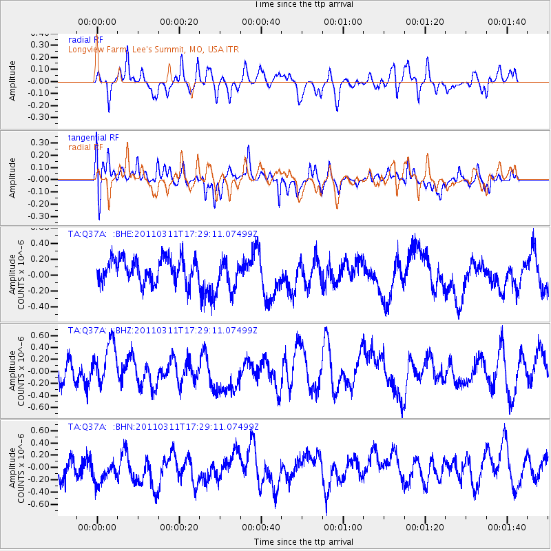
Q37A Longview Farm, Lee's Summit, MO, USA - Earthquake Result Viewer
*The percent match for this event was below the threshold and hence no stack was calculated.
| Earthquake location: |
Off East Coast Of Honshu, Japan |
| Earthquake latitude/longitude: |
37.0/144.2 |
| Earthquake time(UTC): |
2011/03/11 (070) 17:16:56 GMT |
| Earthquake Depth: |
9.3 km |
| Earthquake Magnitude: |
5.5 MB, 5.6 MS |
| Earthquake Catalog/Contributor: |
WHDF/NEIC |
|
| Network: |
TA USArray Transportable Network (new EarthScope stations) |
| Station: |
Q37A Longview Farm, Lee's Summit, MO, USA |
| Lat/Lon: |
38.88 N/94.45 W |
| Elevation: |
297 m |
|
| Distance: |
87.2 deg |
| Az: |
41.846 deg |
| Baz: |
316.824 deg |
| Ray Param: |
$rayparam |
*The percent match for this event was below the threshold and hence was not used in the summary stack. |
|
| Radial Match: |
62.97609 % |
| Radial Bump: |
394 |
| Transverse Match: |
57.121723 % |
| Transverse Bump: |
400 |
| SOD ConfigId: |
356183 |
| Insert Time: |
2011-08-17 14:36:13.047 +0000 |
| GWidth: |
2.5 |
| Max Bumps: |
400 |
| Tol: |
0.001 |
|
Signal To Noise
| Channel | StoN | STA | LTA |
| TA:Q37A: :BHZ:20110311T17:29:11.07499Z | 2.0643182 | 3.9164604E-7 | 1.8972173E-7 |
| TA:Q37A: :BHN:20110311T17:29:11.07499Z | 1.3146253 | 2.8369166E-7 | 2.1579662E-7 |
| TA:Q37A: :BHE:20110311T17:29:11.07499Z | 1.3594995 | 2.0374891E-7 | 1.4987053E-7 |
| Arrivals |
| Ps | |
| PpPs | |
| PsPs/PpSs | |


