You are here: Home > Network List > TA - USArray Transportable Network (new EarthScope stations) Stations List
> Station N34A Lincoln, NE, USA > Earthquake Result Viewer
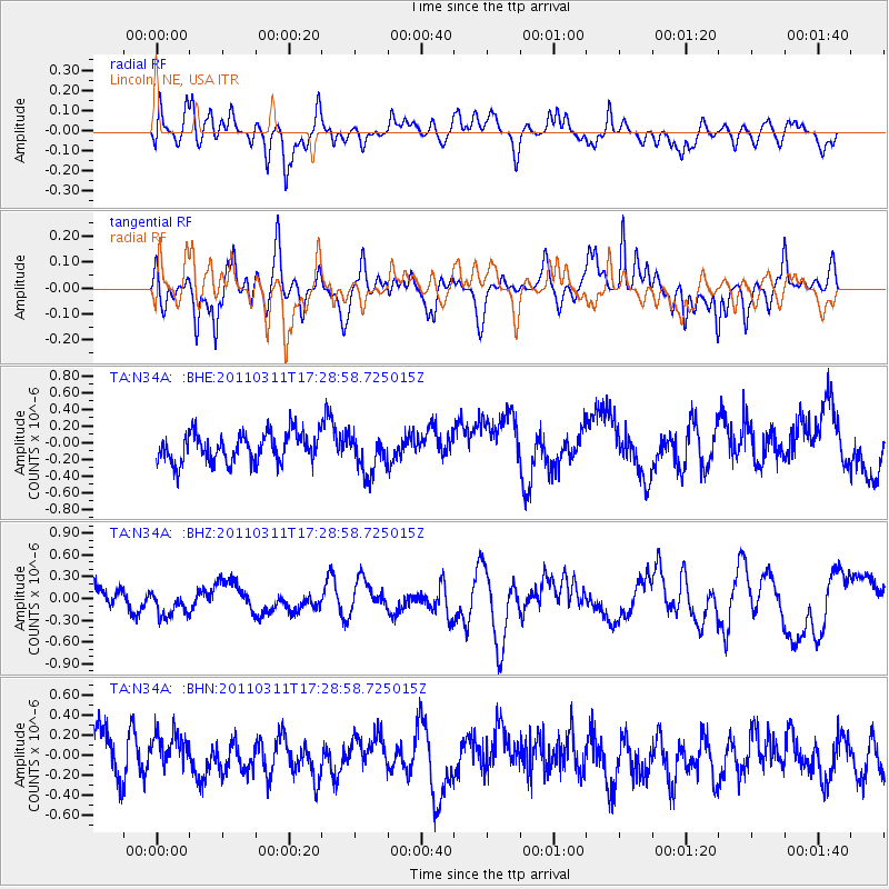
N34A Lincoln, NE, USA - Earthquake Result Viewer
*The percent match for this event was below the threshold and hence no stack was calculated.
| Earthquake location: |
Off East Coast Of Honshu, Japan |
| Earthquake latitude/longitude: |
37.0/144.2 |
| Earthquake time(UTC): |
2011/03/11 (070) 17:16:56 GMT |
| Earthquake Depth: |
9.3 km |
| Earthquake Magnitude: |
5.5 MB, 5.6 MS |
| Earthquake Catalog/Contributor: |
WHDF/NEIC |
|
| Network: |
TA USArray Transportable Network (new EarthScope stations) |
| Station: |
N34A Lincoln, NE, USA |
| Lat/Lon: |
40.84 N/96.50 W |
| Elevation: |
401 m |
|
| Distance: |
84.7 deg |
| Az: |
41.626 deg |
| Baz: |
315.5 deg |
| Ray Param: |
$rayparam |
*The percent match for this event was below the threshold and hence was not used in the summary stack. |
|
| Radial Match: |
51.20375 % |
| Radial Bump: |
400 |
| Transverse Match: |
56.200718 % |
| Transverse Bump: |
369 |
| SOD ConfigId: |
356183 |
| Insert Time: |
2011-08-17 14:38:08.233 +0000 |
| GWidth: |
2.5 |
| Max Bumps: |
400 |
| Tol: |
0.001 |
|
Signal To Noise
| Channel | StoN | STA | LTA |
| TA:N34A: :BHZ:20110311T17:28:58.725015Z | 1.2190809 | 2.570932E-7 | 2.1089102E-7 |
| TA:N34A: :BHN:20110311T17:28:58.725015Z | 0.8296871 | 2.2940938E-7 | 2.7650108E-7 |
| TA:N34A: :BHE:20110311T17:28:58.725015Z | 1.3476919 | 2.3553447E-7 | 1.7476879E-7 |
| Arrivals |
| Ps | |
| PpPs | |
| PsPs/PpSs | |


