You are here: Home > Network List > TA - USArray Transportable Network (new EarthScope stations) Stations List
> Station C38A Sawbill Landing (USFS), Superior Nat. Forest, MN, > Earthquake Result Viewer
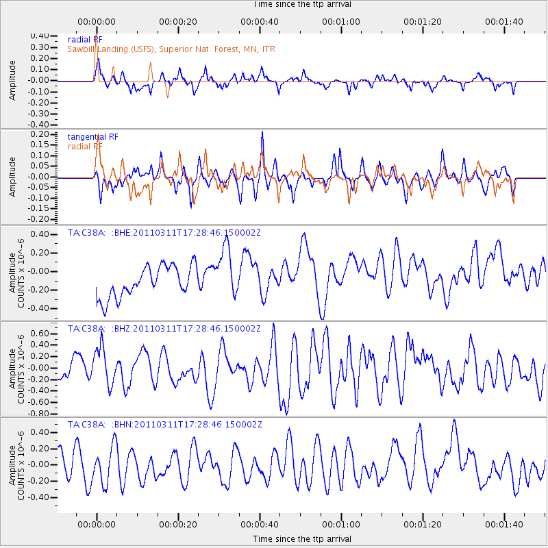
C38A Sawbill Landing (USFS), Superior Nat. Forest, MN, - Earthquake Result Viewer
*The percent match for this event was below the threshold and hence no stack was calculated.
| Earthquake location: |
Off East Coast Of Honshu, Japan |
| Earthquake latitude/longitude: |
37.0/144.2 |
| Earthquake time(UTC): |
2011/03/11 (070) 17:16:56 GMT |
| Earthquake Depth: |
9.3 km |
| Earthquake Magnitude: |
5.5 MB, 5.6 MS |
| Earthquake Catalog/Contributor: |
WHDF/NEIC |
|
| Network: |
TA USArray Transportable Network (new EarthScope stations) |
| Station: |
C38A Sawbill Landing (USFS), Superior Nat. Forest, MN, |
| Lat/Lon: |
47.72 N/91.27 W |
| Elevation: |
498 m |
|
| Distance: |
82.2 deg |
| Az: |
34.139 deg |
| Baz: |
318.29 deg |
| Ray Param: |
$rayparam |
*The percent match for this event was below the threshold and hence was not used in the summary stack. |
|
| Radial Match: |
36.507133 % |
| Radial Bump: |
293 |
| Transverse Match: |
35.30752 % |
| Transverse Bump: |
255 |
| SOD ConfigId: |
356183 |
| Insert Time: |
2011-08-17 14:53:38.547 +0000 |
| GWidth: |
2.5 |
| Max Bumps: |
400 |
| Tol: |
0.001 |
|
Signal To Noise
| Channel | StoN | STA | LTA |
| TA:C38A: :BHZ:20110311T17:28:46.150002Z | 0.97661275 | 3.2196937E-7 | 3.2967966E-7 |
| TA:C38A: :BHN:20110311T17:28:46.150002Z | 1.1434153 | 2.2837784E-7 | 1.9973305E-7 |
| TA:C38A: :BHE:20110311T17:28:46.150002Z | 1.6878653 | 2.7892307E-7 | 1.6525198E-7 |
| Arrivals |
| Ps | |
| PpPs | |
| PsPs/PpSs | |


