You are here: Home > Network List > TA - USArray Transportable Network (new EarthScope stations) Stations List
> Station E36A McGregor, MN, USA > Earthquake Result Viewer
E36A McGregor, MN, USA - Earthquake Result Viewer
*The percent match for this event was below the threshold and hence no stack was calculated.
| Earthquake location: |
Off East Coast Of Honshu, Japan |
| Earthquake latitude/longitude: |
37.0/144.2 |
| Earthquake time(UTC): |
2011/03/11 (070) 17:16:56 GMT |
| Earthquake Depth: |
9.3 km |
| Earthquake Magnitude: |
5.5 MB, 5.6 MS |
| Earthquake Catalog/Contributor: |
WHDF/NEIC |
|
| Network: |
TA USArray Transportable Network (new EarthScope stations) |
| Station: |
E36A McGregor, MN, USA |
| Lat/Lon: |
46.52 N/93.26 W |
| Elevation: |
393 m |
|
| Distance: |
82.2 deg |
| Az: |
35.965 deg |
| Baz: |
317.089 deg |
| Ray Param: |
$rayparam |
*The percent match for this event was below the threshold and hence was not used in the summary stack. |
|
| Radial Match: |
69.72549 % |
| Radial Bump: |
400 |
| Transverse Match: |
40.723694 % |
| Transverse Bump: |
352 |
| SOD ConfigId: |
356183 |
| Insert Time: |
2011-08-17 14:55:10.376 +0000 |
| GWidth: |
2.5 |
| Max Bumps: |
400 |
| Tol: |
0.001 |
|
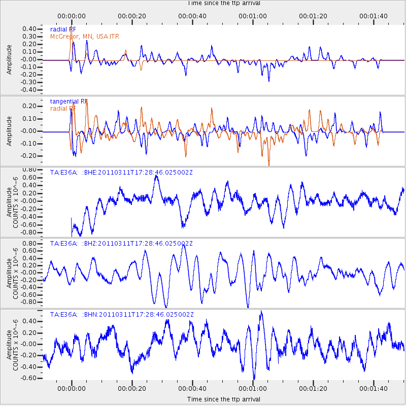
Signal To Noise
| Channel | StoN | STA | LTA |
| TA:E36A: :BHZ:20110311T17:28:46.025002Z | 0.6216261 | 2.6051663E-7 | 4.1908896E-7 |
| TA:E36A: :BHN:20110311T17:28:46.025002Z | 0.673434 | 1.5535471E-7 | 2.3069032E-7 |
| TA:E36A: :BHE:20110311T17:28:46.025002Z | 0.8194929 | 2.7347585E-7 | 3.337135E-7 |
| Arrivals |
| Ps | |
| PpPs | |
| PsPs/PpSs | |


