You are here: Home > Network List > TA - USArray Transportable Network (new EarthScope stations) Stations List
> Station R11A Troy Canyon, Currant, NV, USA > Earthquake Result Viewer
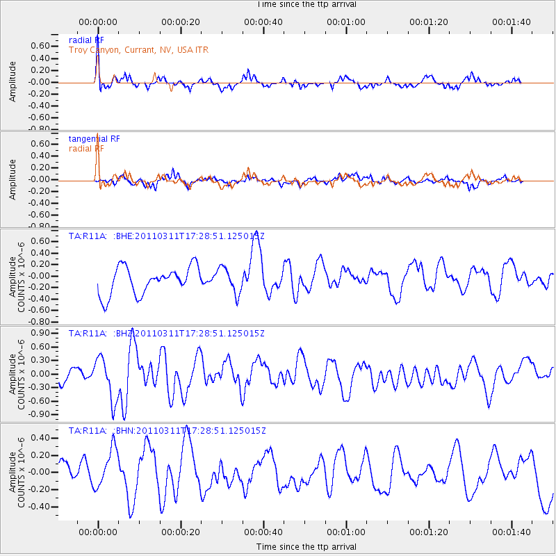
R11A Troy Canyon, Currant, NV, USA - Earthquake Result Viewer
*The percent match for this event was below the threshold and hence no stack was calculated.
| Earthquake location: |
Near East Coast Of Honshu, Japan |
| Earthquake latitude/longitude: |
35.3/141.4 |
| Earthquake time(UTC): |
2011/03/11 (070) 17:17:23 GMT |
| Earthquake Depth: |
1.7 km |
| Earthquake Magnitude: |
5.5 MB |
| Earthquake Catalog/Contributor: |
WHDF/NEIC |
|
| Network: |
TA USArray Transportable Network (new EarthScope stations) |
| Station: |
R11A Troy Canyon, Currant, NV, USA |
| Lat/Lon: |
38.35 N/115.59 W |
| Elevation: |
1756 m |
|
| Distance: |
77.8 deg |
| Az: |
51.597 deg |
| Baz: |
305.419 deg |
| Ray Param: |
$rayparam |
*The percent match for this event was below the threshold and hence was not used in the summary stack. |
|
| Radial Match: |
72.890495 % |
| Radial Bump: |
400 |
| Transverse Match: |
58.70784 % |
| Transverse Bump: |
371 |
| SOD ConfigId: |
356183 |
| Insert Time: |
2011-08-17 16:26:10.848 +0000 |
| GWidth: |
2.5 |
| Max Bumps: |
400 |
| Tol: |
0.001 |
|
Signal To Noise
| Channel | StoN | STA | LTA |
| TA:R11A: :BHZ:20110311T17:28:51.125015Z | 2.9776034 | 4.8976597E-7 | 1.6448327E-7 |
| TA:R11A: :BHN:20110311T17:28:51.125015Z | 1.2438072 | 2.6111616E-7 | 2.0993299E-7 |
| TA:R11A: :BHE:20110311T17:28:51.125015Z | 0.96263975 | 2.2956571E-7 | 2.3847522E-7 |
| Arrivals |
| Ps | |
| PpPs | |
| PsPs/PpSs | |


