You are here: Home > Network List > TA - USArray Transportable Network (new EarthScope stations) Stations List
> Station Z35A Perchaven, Sanger, TX, USA > Earthquake Result Viewer
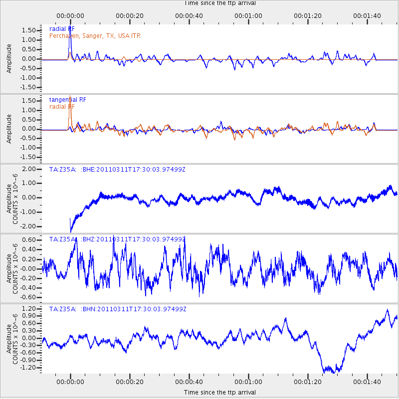
Z35A Perchaven, Sanger, TX, USA - Earthquake Result Viewer
*The percent match for this event was below the threshold and hence no stack was calculated.
| Earthquake location: |
Near East Coast Of Honshu, Japan |
| Earthquake latitude/longitude: |
35.3/141.4 |
| Earthquake time(UTC): |
2011/03/11 (070) 17:17:23 GMT |
| Earthquake Depth: |
1.7 km |
| Earthquake Magnitude: |
5.5 MB |
| Earthquake Catalog/Contributor: |
WHDF/NEIC |
|
| Network: |
TA USArray Transportable Network (new EarthScope stations) |
| Station: |
Z35A Perchaven, Sanger, TX, USA |
| Lat/Lon: |
33.33 N/97.25 W |
| Elevation: |
235 m |
|
| Distance: |
92.4 deg |
| Az: |
45.687 deg |
| Baz: |
315.667 deg |
| Ray Param: |
$rayparam |
*The percent match for this event was below the threshold and hence was not used in the summary stack. |
|
| Radial Match: |
50.22206 % |
| Radial Bump: |
371 |
| Transverse Match: |
25.002872 % |
| Transverse Bump: |
249 |
| SOD ConfigId: |
356183 |
| Insert Time: |
2011-08-17 16:49:04.153 +0000 |
| GWidth: |
2.5 |
| Max Bumps: |
400 |
| Tol: |
0.001 |
|
Signal To Noise
| Channel | StoN | STA | LTA |
| TA:Z35A: :BHZ:20110311T17:30:03.97499Z | 1.4422238 | 4.3287886E-7 | 3.001468E-7 |
| TA:Z35A: :BHN:20110311T17:30:03.97499Z | 0.76828045 | 4.5754584E-7 | 5.955453E-7 |
| TA:Z35A: :BHE:20110311T17:30:03.97499Z | 0.39315298 | 2.4196615E-7 | 6.1545035E-7 |
| Arrivals |
| Ps | |
| PpPs | |
| PsPs/PpSs | |


