You are here: Home > Network List > TA - USArray Transportable Network (new EarthScope stations) Stations List
> Station R11A Troy Canyon, Currant, NV, USA > Earthquake Result Viewer
R11A Troy Canyon, Currant, NV, USA - Earthquake Result Viewer
*The percent match for this event was below the threshold and hence no stack was calculated.
| Earthquake location: |
South Of Kermadec Islands |
| Earthquake latitude/longitude: |
-34.8/-179.4 |
| Earthquake time(UTC): |
2014/02/18 (049) 08:14:42 GMT |
| Earthquake Depth: |
27 km |
| Earthquake Magnitude: |
5.6 MWC, 5.6 MWC |
| Earthquake Catalog/Contributor: |
NEIC PDE/NEIC COMCAT |
|
| Network: |
TA USArray Transportable Network (new EarthScope stations) |
| Station: |
R11A Troy Canyon, Currant, NV, USA |
| Lat/Lon: |
38.35 N/115.59 W |
| Elevation: |
1756 m |
|
| Distance: |
93.8 deg |
| Az: |
45.008 deg |
| Baz: |
227.749 deg |
| Ray Param: |
$rayparam |
*The percent match for this event was below the threshold and hence was not used in the summary stack. |
|
| Radial Match: |
74.27043 % |
| Radial Bump: |
400 |
| Transverse Match: |
63.27393 % |
| Transverse Bump: |
400 |
| SOD ConfigId: |
3390531 |
| Insert Time: |
2019-04-10 09:08:33.509 +0000 |
| GWidth: |
2.5 |
| Max Bumps: |
400 |
| Tol: |
0.001 |
|
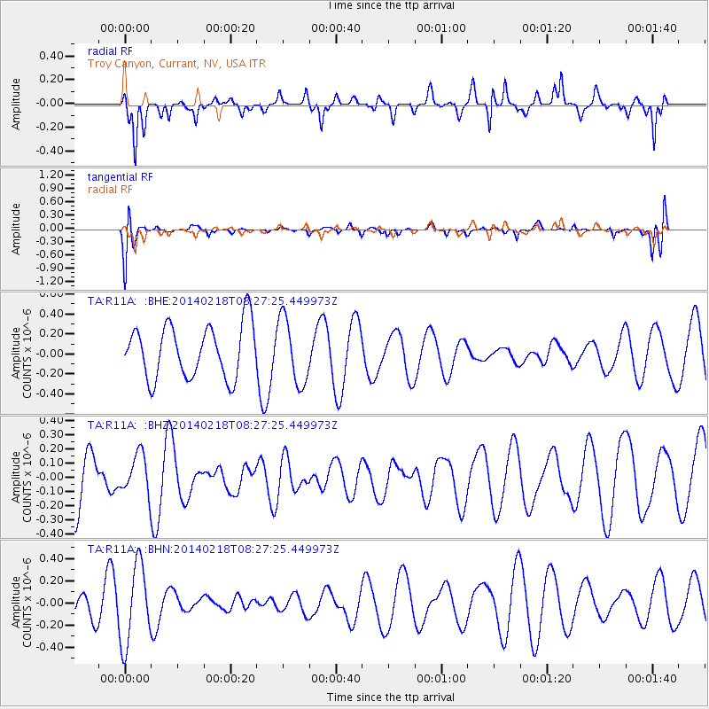
Signal To Noise
| Channel | StoN | STA | LTA |
| TA:R11A: :BHZ:20140218T08:27:25.449973Z | 0.55461913 | 1.438957E-7 | 2.5944962E-7 |
| TA:R11A: :BHN:20140218T08:27:25.449973Z | 2.1247692 | 3.6203375E-7 | 1.7038734E-7 |
| TA:R11A: :BHE:20140218T08:27:25.449973Z | 1.2621051 | 3.3308086E-7 | 2.63909E-7 |
| Arrivals |
| Ps | |
| PpPs | |
| PsPs/PpSs | |


