You are here: Home > Network List > TA - USArray Transportable Network (new EarthScope stations) Stations List
> Station 338A Crockett, TX, USA > Earthquake Result Viewer
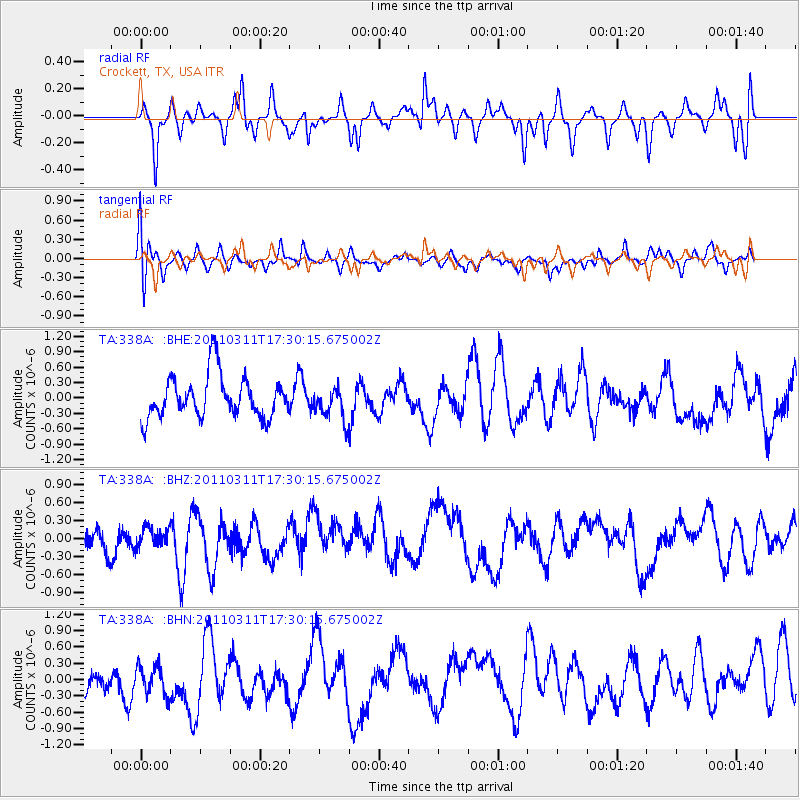
338A Crockett, TX, USA - Earthquake Result Viewer
*The percent match for this event was below the threshold and hence no stack was calculated.
| Earthquake location: |
Near East Coast Of Honshu, Japan |
| Earthquake latitude/longitude: |
35.3/141.4 |
| Earthquake time(UTC): |
2011/03/11 (070) 17:17:23 GMT |
| Earthquake Depth: |
1.7 km |
| Earthquake Magnitude: |
5.5 MB |
| Earthquake Catalog/Contributor: |
WHDF/NEIC |
|
| Network: |
TA USArray Transportable Network (new EarthScope stations) |
| Station: |
338A Crockett, TX, USA |
| Lat/Lon: |
31.36 N/95.31 W |
| Elevation: |
137 m |
|
| Distance: |
94.9 deg |
| Az: |
45.864 deg |
| Baz: |
316.69 deg |
| Ray Param: |
$rayparam |
*The percent match for this event was below the threshold and hence was not used in the summary stack. |
|
| Radial Match: |
51.039036 % |
| Radial Bump: |
308 |
| Transverse Match: |
48.940327 % |
| Transverse Bump: |
400 |
| SOD ConfigId: |
356183 |
| Insert Time: |
2011-08-17 16:56:23.248 +0000 |
| GWidth: |
2.5 |
| Max Bumps: |
400 |
| Tol: |
0.001 |
|
Signal To Noise
| Channel | StoN | STA | LTA |
| TA:338A: :BHZ:20110311T17:30:15.675002Z | 0.5971252 | 1.4543261E-7 | 2.4355464E-7 |
| TA:338A: :BHN:20110311T17:30:15.675002Z | 0.81929654 | 3.1936867E-7 | 3.8980838E-7 |
| TA:338A: :BHE:20110311T17:30:15.675002Z | 0.77927095 | 3.2279607E-7 | 4.1422828E-7 |
| Arrivals |
| Ps | |
| PpPs | |
| PsPs/PpSs | |


