You are here: Home > Network List > TA - USArray Transportable Network (new EarthScope stations) Stations List
> Station U37A Salina, OK, USA > Earthquake Result Viewer
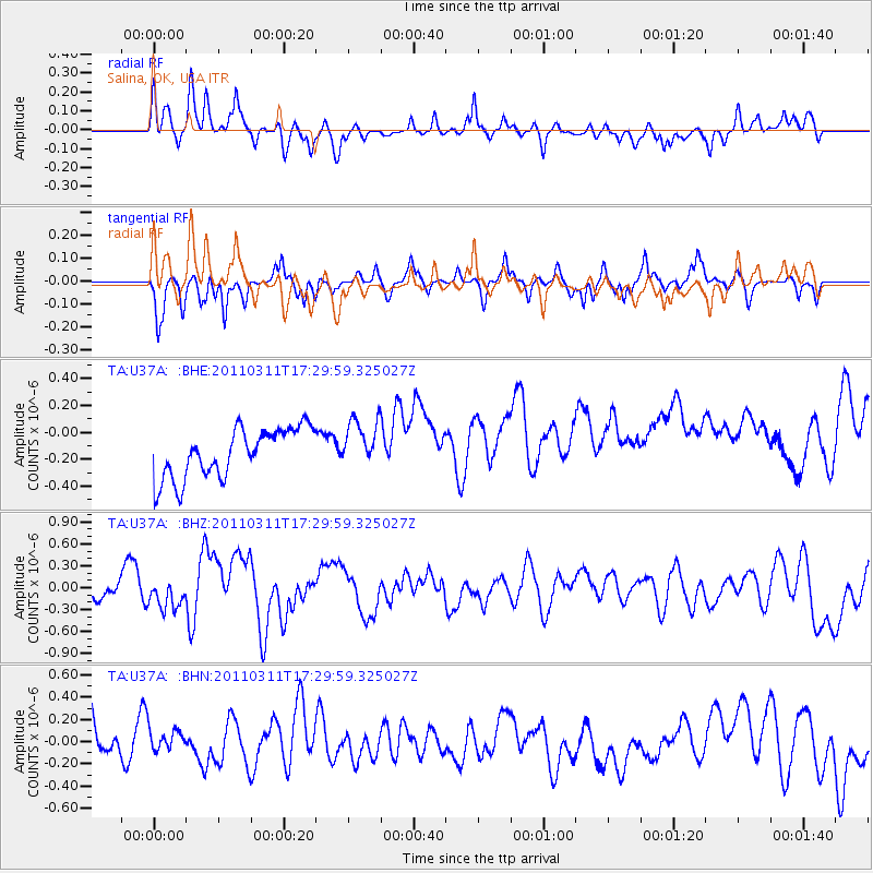
U37A Salina, OK, USA - Earthquake Result Viewer
*The percent match for this event was below the threshold and hence no stack was calculated.
| Earthquake location: |
Near East Coast Of Honshu, Japan |
| Earthquake latitude/longitude: |
35.3/141.4 |
| Earthquake time(UTC): |
2011/03/11 (070) 17:17:23 GMT |
| Earthquake Depth: |
1.7 km |
| Earthquake Magnitude: |
5.5 MB |
| Earthquake Catalog/Contributor: |
WHDF/NEIC |
|
| Network: |
TA USArray Transportable Network (new EarthScope stations) |
| Station: |
U37A Salina, OK, USA |
| Lat/Lon: |
36.41 N/95.12 W |
| Elevation: |
248 m |
|
| Distance: |
91.4 deg |
| Az: |
42.296 deg |
| Baz: |
316.994 deg |
| Ray Param: |
$rayparam |
*The percent match for this event was below the threshold and hence was not used in the summary stack. |
|
| Radial Match: |
50.04831 % |
| Radial Bump: |
324 |
| Transverse Match: |
43.93901 % |
| Transverse Bump: |
249 |
| SOD ConfigId: |
356183 |
| Insert Time: |
2011-08-17 17:03:52.184 +0000 |
| GWidth: |
2.5 |
| Max Bumps: |
400 |
| Tol: |
0.001 |
|
Signal To Noise
| Channel | StoN | STA | LTA |
| TA:U37A: :BHZ:20110311T17:29:59.325027Z | 0.5671454 | 1.3868267E-7 | 2.4452754E-7 |
| TA:U37A: :BHN:20110311T17:29:59.325027Z | 0.67647487 | 9.7587545E-8 | 1.4425895E-7 |
| TA:U37A: :BHE:20110311T17:29:59.325027Z | 0.9981748 | 1.8274997E-7 | 1.8308414E-7 |
| Arrivals |
| Ps | |
| PpPs | |
| PsPs/PpSs | |


