You are here: Home > Network List > CI - Caltech Regional Seismic Network Stations List
> Station LGU LGU, Camarillo, CA, USA > Earthquake Result Viewer
LGU LGU, Camarillo, CA, USA - Earthquake Result Viewer
| Earthquake location: |
Fox Islands, Aleutian Islands |
| Earthquake latitude/longitude: |
54.0/-166.4 |
| Earthquake time(UTC): |
2006/09/01 (244) 12:04:22 GMT |
| Earthquake Depth: |
76 km |
| Earthquake Magnitude: |
5.8 MB, 5.9 MW |
| Earthquake Catalog/Contributor: |
WHDF/NEIC |
|
| Network: |
CI Caltech Regional Seismic Network |
| Station: |
LGU LGU, Camarillo, CA, USA |
| Lat/Lon: |
34.11 N/119.07 W |
| Elevation: |
416 m |
|
| Distance: |
38.5 deg |
| Az: |
101.49 deg |
| Baz: |
315.752 deg |
| Ray Param: |
0.075292744 |
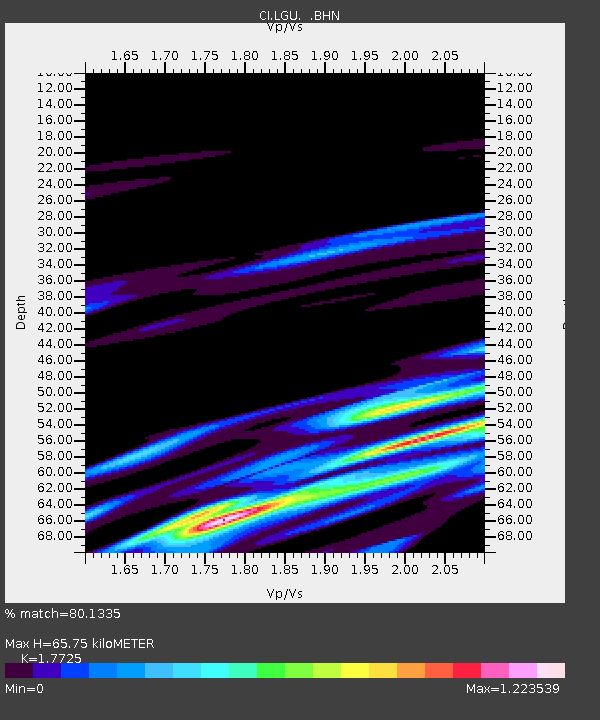
| Estimated Moho Depth: |
65.75 km |
| Estimated Crust Vp/Vs: |
1.77 |
| Assumed Crust Vp: |
6.1 km/s |
| Estimated Crust Vs: |
3.441 km/s |
| Estimated Crust Poisson's Ratio: |
0.27 |
|
| Radial Match: |
80.1335 % |
| Radial Bump: |
342 |
| Transverse Match: |
55.59186 % |
| Transverse Bump: |
400 |
| SOD ConfigId: |
2665 |
| Insert Time: |
2010-02-25 20:13:41.196 +0000 |
| GWidth: |
2.5 |
| Max Bumps: |
400 |
| Tol: |
0.001 |
|
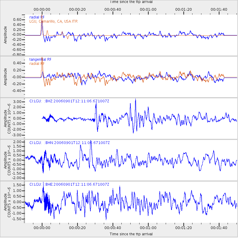
Signal To Noise
| Channel | StoN | STA | LTA |
| CI:LGU: :BHN:20060901T12:11:06.671007Z | 1.3637449 | 5.475204E-7 | 4.0148302E-7 |
| CI:LGU: :BHE:20060901T12:11:06.671007Z | 1.9092759 | 6.005137E-7 | 3.1452433E-7 |
| CI:LGU: :BHZ:20060901T12:11:06.671007Z | 5.053522 | 1.1151798E-6 | 2.2067377E-7 |
| Arrivals |
| Ps | 8.9 SECOND |
| PpPs | 28 SECOND |
| PsPs/PpSs | 37 SECOND |


