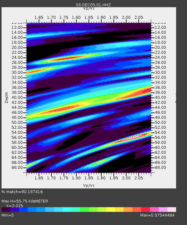
DEC05 Apollo Drive Surface Site - Earthquake Result Viewer

Earthquake location: North Atlantic Ocean
Earthquake latitude/longitude: 14.7/-58.9
Earthquake time(UTC): 2014/02/18 (049) 09:27:13 GMT
Earthquake Depth: 17 km
Earthquake Magnitude: 6.5 MWW, 6.3 MWB, 6.5 MWC, 6.6 MWC, 6.7 MI
Earthquake Catalog/Contributor: NEIC PDE/NEIC COMCAT
Network: GS US Geological Survey Networks
Station: DEC05 Apollo Drive Surface Site
Lat/Lon: 39.87 N/88.87 W
Elevation: 216 m
Distance: 36.3 deg
Az: 319.544 deg
Baz: 125.31 deg
Ray Param: 0.0767433
Estimated Moho Depth: 55.75 km
Estimated Crust Vp/Vs: 2.03
Assumed Crust Vp: 6.444 km/s
Estimated Crust Vs: 3.182 km/s
Estimated Crust Poisson's Ratio: 0.34
Radial Match: 90.187416 %
Radial Bump: 400
Transverse Match: 79.54917 %
Transverse Bump: 400
SOD ConfigId: 3390531
Insert Time: 2019-04-10 09:11:22.224 +0000
GWidth: 2.5
Max Bumps: 400
Tol: 0.001

Signal To Noise

ChannelStoNSTALTA
GS:DEC05:01:HHZ:20140218T09:33:45.395013Z8.6205353.2241035E-63.740027E-7
GS:DEC05:01:HHN:20140218T09:33:45.395013Z1.819031.052878E-65.788129E-7
GS:DEC05:01:HHE:20140218T09:33:45.395013Z1.5773931.5438336E-69.787246E-7
Arrivals
Ps9.5 SECOND
PpPs25 SECOND
PsPs/PpSs34 SECOND