You are here: Home > Network List > GT - Global Telemetered Seismograph Network (USAF/USGS) Stations List
> Station CPUP Villa Florida, Paraguay > Earthquake Result Viewer
CPUP Villa Florida, Paraguay - Earthquake Result Viewer
| Earthquake location: |
North Atlantic Ocean |
| Earthquake latitude/longitude: |
14.7/-58.9 |
| Earthquake time(UTC): |
2014/02/18 (049) 09:27:13 GMT |
| Earthquake Depth: |
17 km |
| Earthquake Magnitude: |
6.5 MWW, 6.3 MWB, 6.5 MWC, 6.6 MWC, 6.7 MI |
| Earthquake Catalog/Contributor: |
NEIC PDE/NEIC COMCAT |
|
| Network: |
GT Global Telemetered Seismograph Network (USAF/USGS) |
| Station: |
CPUP Villa Florida, Paraguay |
| Lat/Lon: |
26.33 S/57.33 W |
| Elevation: |
105 m |
|
| Distance: |
40.8 deg |
| Az: |
177.803 deg |
| Baz: |
357.63 deg |
| Ray Param: |
0.07419116 |
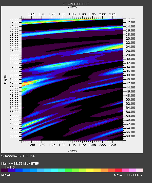
| Estimated Moho Depth: |
43.25 km |
| Estimated Crust Vp/Vs: |
1.60 |
| Assumed Crust Vp: |
6.498 km/s |
| Estimated Crust Vs: |
4.061 km/s |
| Estimated Crust Poisson's Ratio: |
0.18 |
|
| Radial Match: |
92.189354 % |
| Radial Bump: |
308 |
| Transverse Match: |
62.348045 % |
| Transverse Bump: |
400 |
| SOD ConfigId: |
3390531 |
| Insert Time: |
2019-04-10 09:11:28.550 +0000 |
| GWidth: |
2.5 |
| Max Bumps: |
400 |
| Tol: |
0.001 |
|

Signal To Noise
| Channel | StoN | STA | LTA |
| GT:CPUP:00:BHZ:20140218T09:34:22.325006Z | 27.266594 | 3.9143006E-6 | 1.4355663E-7 |
| GT:CPUP:00:BHN:20140218T09:34:22.325006Z | 20.122957 | 2.4191759E-6 | 1.202197E-7 |
| GT:CPUP:00:BHE:20140218T09:34:22.325006Z | 2.5452209 | 2.2671185E-7 | 8.9073545E-8 |
| Arrivals |
| Ps | 4.3 SECOND |
| PpPs | 16 SECOND |
| PsPs/PpSs | 20 SECOND |


