You are here: Home > Network List > II - Global Seismograph Network (GSN - IRIS/IDA) Stations List
> Station HOPE Hope Point, South Georgia Island > Earthquake Result Viewer
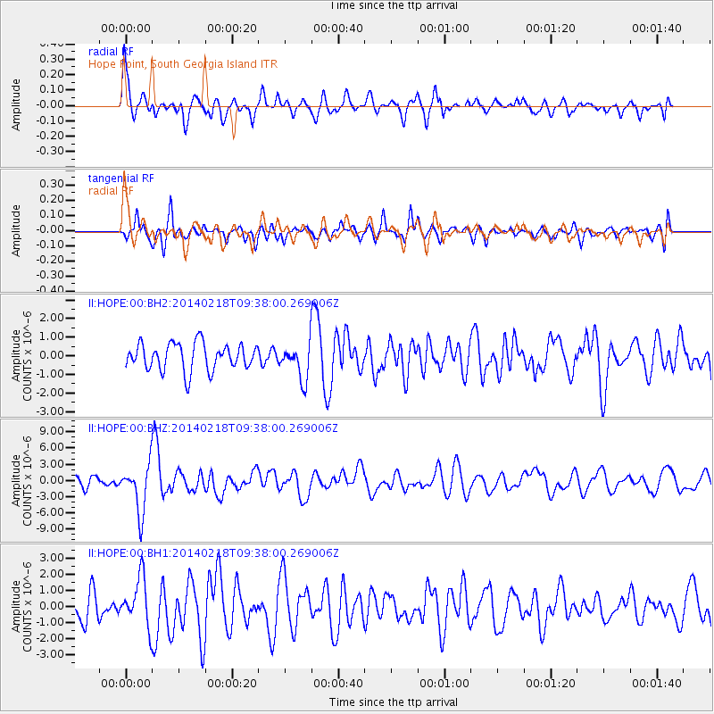
HOPE Hope Point, South Georgia Island - Earthquake Result Viewer
*The percent match for this event was below the threshold and hence no stack was calculated.
| Earthquake location: |
North Atlantic Ocean |
| Earthquake latitude/longitude: |
14.7/-58.9 |
| Earthquake time(UTC): |
2014/02/18 (049) 09:27:13 GMT |
| Earthquake Depth: |
17 km |
| Earthquake Magnitude: |
6.5 MWW, 6.3 MWB, 6.5 MWC, 6.6 MWC, 6.7 MI |
| Earthquake Catalog/Contributor: |
NEIC PDE/NEIC COMCAT |
|
| Network: |
II Global Seismograph Network (GSN - IRIS/IDA) |
| Station: |
HOPE Hope Point, South Georgia Island |
| Lat/Lon: |
54.28 S/36.49 W |
| Elevation: |
20 m |
|
| Distance: |
71.3 deg |
| Az: |
166.329 deg |
| Baz: |
337.038 deg |
| Ray Param: |
$rayparam |
*The percent match for this event was below the threshold and hence was not used in the summary stack. |
|
| Radial Match: |
70.58452 % |
| Radial Bump: |
400 |
| Transverse Match: |
69.635765 % |
| Transverse Bump: |
400 |
| SOD ConfigId: |
3390531 |
| Insert Time: |
2019-04-10 09:11:34.457 +0000 |
| GWidth: |
2.5 |
| Max Bumps: |
400 |
| Tol: |
0.001 |
|
Signal To Noise
| Channel | StoN | STA | LTA |
| II:HOPE:00:BHZ:20140218T09:38:00.269006Z | 5.712685 | 4.467763E-6 | 7.8207756E-7 |
| II:HOPE:00:BH1:20140218T09:38:00.269006Z | 1.8789299 | 1.5082886E-6 | 8.0273816E-7 |
| II:HOPE:00:BH2:20140218T09:38:00.269006Z | 1.4830287 | 1.0746312E-6 | 7.246193E-7 |
| Arrivals |
| Ps | |
| PpPs | |
| PsPs/PpSs | |


