You are here: Home > Network List > TA - USArray Transportable Network (new EarthScope stations) Stations List
> Station J37A Redenius Farm, Forest, IA, USA > Earthquake Result Viewer
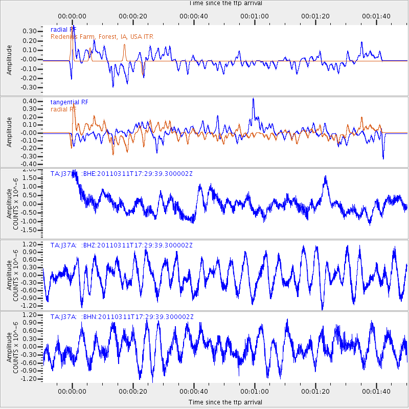
J37A Redenius Farm, Forest, IA, USA - Earthquake Result Viewer
*The percent match for this event was below the threshold and hence no stack was calculated.
| Earthquake location: |
Near East Coast Of Honshu, Japan |
| Earthquake latitude/longitude: |
35.3/141.4 |
| Earthquake time(UTC): |
2011/03/11 (070) 17:17:23 GMT |
| Earthquake Depth: |
1.7 km |
| Earthquake Magnitude: |
5.5 MB |
| Earthquake Catalog/Contributor: |
WHDF/NEIC |
|
| Network: |
TA USArray Transportable Network (new EarthScope stations) |
| Station: |
J37A Redenius Farm, Forest, IA, USA |
| Lat/Lon: |
43.31 N/93.55 W |
| Elevation: |
385 m |
|
| Distance: |
87.1 deg |
| Az: |
36.748 deg |
| Baz: |
317.919 deg |
| Ray Param: |
$rayparam |
*The percent match for this event was below the threshold and hence was not used in the summary stack. |
|
| Radial Match: |
47.153835 % |
| Radial Bump: |
400 |
| Transverse Match: |
36.803097 % |
| Transverse Bump: |
370 |
| SOD ConfigId: |
356183 |
| Insert Time: |
2011-08-17 17:21:05.938 +0000 |
| GWidth: |
2.5 |
| Max Bumps: |
400 |
| Tol: |
0.001 |
|
Signal To Noise
| Channel | StoN | STA | LTA |
| TA:J37A: :BHZ:20110311T17:29:39.300002Z | 1.1997136 | 5.1368613E-7 | 4.2817396E-7 |
| TA:J37A: :BHN:20110311T17:29:39.300002Z | 1.0345316 | 4.1575802E-7 | 4.0188047E-7 |
| TA:J37A: :BHE:20110311T17:29:39.300002Z | 0.6162571 | 3.6295134E-7 | 5.889609E-7 |
| Arrivals |
| Ps | |
| PpPs | |
| PsPs/PpSs | |


