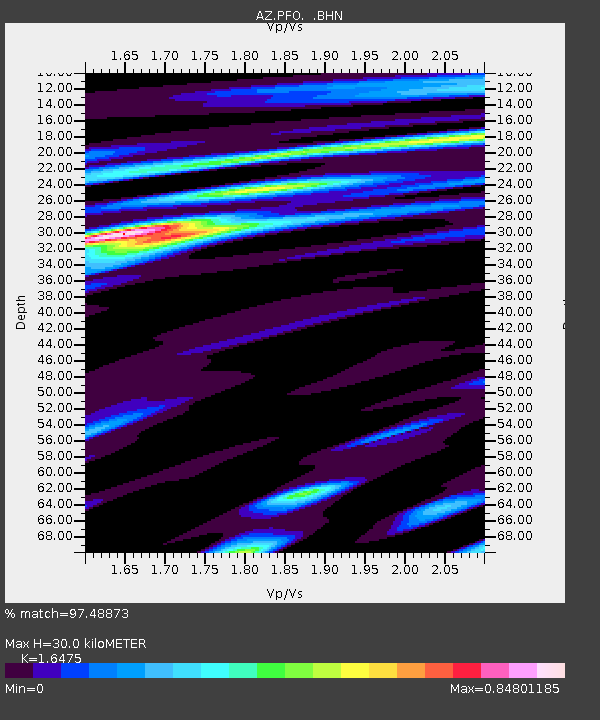
PFO AZ.PFO - Earthquake Result Viewer

Earthquake location: Volcano Islands, Japan Region
Earthquake latitude/longitude: 22.3/143.7
Earthquake time(UTC): 2000/03/28 (088) 11:00:22 GMT
Earthquake Depth: 126 km
Earthquake Magnitude: 6.8 MB, 7.6 MS, 7.6 MW, 7.6 MW
Earthquake Catalog/Contributor: WHDF/NEIC
Network: AZ ANZA Regional Network
Station: PFO AZ.PFO
Lat/Lon: 33.61 N/116.46 W
Elevation: 1259 m
Distance: 85.6 deg
Az: 55.561 deg
Baz: 293.795 deg
Ray Param: 0.0443646
Estimated Moho Depth: 30.0 km
Estimated Crust Vp/Vs: 1.65
Assumed Crust Vp: 6.264 km/s
Estimated Crust Vs: 3.802 km/s
Estimated Crust Poisson's Ratio: 0.21
Radial Match: 97.48873 %
Radial Bump: 400
Transverse Match: 94.578674 %
Transverse Bump: 400
SOD ConfigId: 3744
Insert Time: 2010-02-26 20:16:48.360 +0000
GWidth: 2.5
Max Bumps: 400
Tol: 0.001

Signal To Noise

ChannelStoNSTALTA
AZ:PFO: :BHN:20000328T11:12:15.624014Z1.31977022.780647E-72.1069177E-7
AZ:PFO: :BHE:20000328T11:12:15.624014Z1.71836054.333293E-72.52176E-7
AZ:PFO: :BHZ:20000328T11:12:15.624014Z2.36024027.164803E-73.0356244E-7
Arrivals
Ps3.2 SECOND
PpPs12 SECOND
PsPs/PpSs16 SECOND