You are here: Home > Network List > US - United States National Seismic Network Stations List
> Station ELK Elko, Nevada, USA > Earthquake Result Viewer
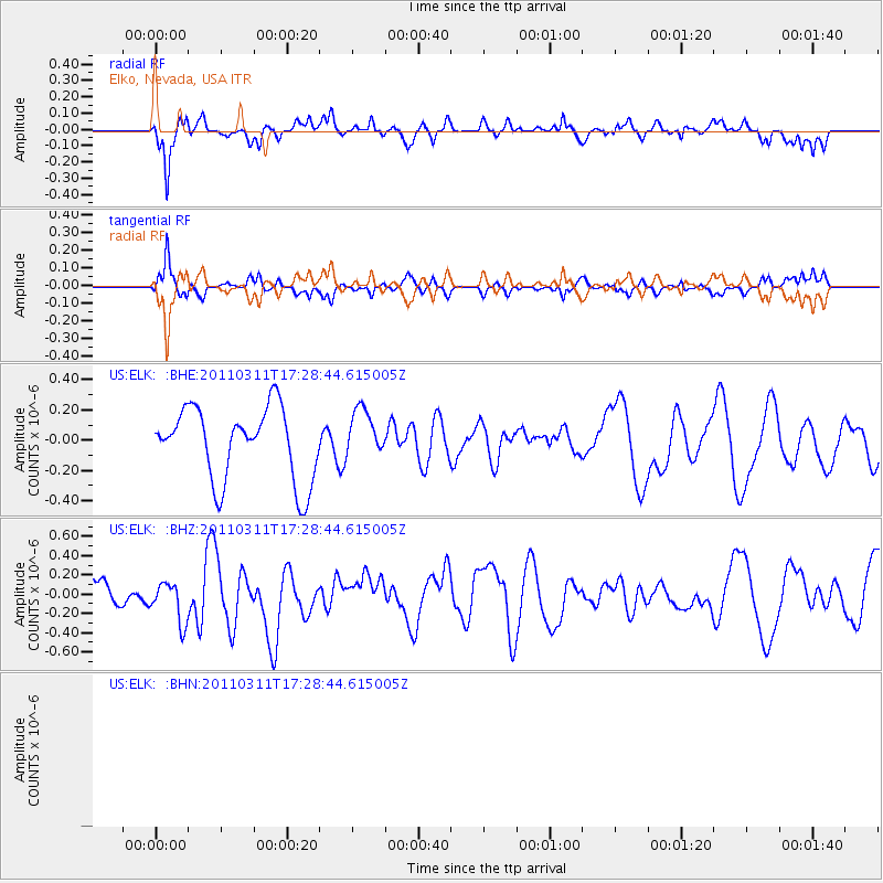
ELK Elko, Nevada, USA - Earthquake Result Viewer
*The percent match for this event was below the threshold and hence no stack was calculated.
| Earthquake location: |
Near East Coast Of Honshu, Japan |
| Earthquake latitude/longitude: |
35.3/141.4 |
| Earthquake time(UTC): |
2011/03/11 (070) 17:17:23 GMT |
| Earthquake Depth: |
1.7 km |
| Earthquake Magnitude: |
5.5 MB |
| Earthquake Catalog/Contributor: |
WHDF/NEIC |
|
| Network: |
US United States National Seismic Network |
| Station: |
ELK Elko, Nevada, USA |
| Lat/Lon: |
40.74 N/115.24 W |
| Elevation: |
2210 m |
|
| Distance: |
76.7 deg |
| Az: |
49.436 deg |
| Baz: |
305.161 deg |
| Ray Param: |
$rayparam |
*The percent match for this event was below the threshold and hence was not used in the summary stack. |
|
| Radial Match: |
67.96667 % |
| Radial Bump: |
393 |
| Transverse Match: |
67.95977 % |
| Transverse Bump: |
389 |
| SOD ConfigId: |
356183 |
| Insert Time: |
2011-08-17 17:38:24.793 +0000 |
| GWidth: |
2.5 |
| Max Bumps: |
400 |
| Tol: |
0.001 |
|
Signal To Noise
| Channel | StoN | STA | LTA |
| US:ELK: :BHZ:20110311T17:28:44.615005Z | 1.1101011 | 2.1884681E-7 | 1.9714133E-7 |
| $trig.getChannelId() | $trig.getValue() | $trig.getSTA() | $trig.getLTA() |
| US:ELK: :BHE:20110311T17:28:44.615005Z | 0.685745 | 1.6332234E-7 | 2.3816774E-7 |
| Arrivals |
| Ps | |
| PpPs | |
| PsPs/PpSs | |


