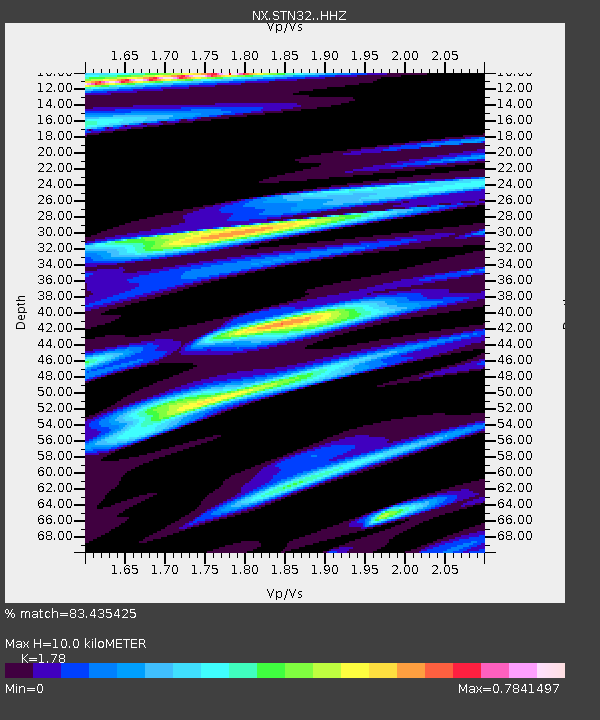
STN32 Seismic station 27 - Earthquake Result Viewer

Earthquake location: North Atlantic Ocean
Earthquake latitude/longitude: 14.7/-58.9
Earthquake time(UTC): 2014/02/18 (049) 09:27:13 GMT
Earthquake Depth: 17 km
Earthquake Magnitude: 6.5 MWW, 6.3 MWB, 6.5 MWC, 6.6 MWC, 6.7 MI
Earthquake Catalog/Contributor: NEIC PDE/NEIC COMCAT
Network: NX Nanometrics Research Network
Station: STN32 Seismic station 27
Lat/Lon: 35.68 N/97.16 W
Elevation: 292 m
Distance: 40.1 deg
Az: 308.541 deg
Baz: 111.582 deg
Ray Param: 0.07457343
Estimated Moho Depth: 10.0 km
Estimated Crust Vp/Vs: 1.78
Assumed Crust Vp: 6.426 km/s
Estimated Crust Vs: 3.61 km/s
Estimated Crust Poisson's Ratio: 0.27
Radial Match: 83.435425 %
Radial Bump: 334
Transverse Match: 76.93112 %
Transverse Bump: 400
SOD ConfigId: 3390531
Insert Time: 2019-04-10 09:12:28.220 +0000
GWidth: 2.5
Max Bumps: 400
Tol: 0.001

Signal To Noise

ChannelStoNSTALTA
NX:STN32: :HHZ:20140218T09:34:17.240015Z6.45139362.5353393E-63.9299093E-7
NX:STN32: :HH1:20140218T09:34:17.240015Z2.089037.788986E-73.728518E-7
NX:STN32: :HH2:20140218T09:34:17.240015Z2.38541469.451266E-73.962106E-7
Arrivals
Ps1.3 SECOND
PpPs4.0 SECOND
PsPs/PpSs5.3 SECOND