You are here: Home > Network List > X812 - Deep Structure of Three Continental Sutures in Eastern North America Stations List
> Station QM28 6 mile checkpoint, Maine, USA > Earthquake Result Viewer
QM28 6 mile checkpoint, Maine, USA - Earthquake Result Viewer
| Earthquake location: |
North Atlantic Ocean |
| Earthquake latitude/longitude: |
14.7/-58.9 |
| Earthquake time(UTC): |
2014/02/18 (049) 09:27:13 GMT |
| Earthquake Depth: |
17 km |
| Earthquake Magnitude: |
6.5 MWW, 6.3 MWB, 6.5 MWC, 6.6 MWC, 6.7 MI |
| Earthquake Catalog/Contributor: |
NEIC PDE/NEIC COMCAT |
|
| Network: |
X8 Deep Structure of Three Continental Sutures in Eastern North America |
| Station: |
QM28 6 mile checkpoint, Maine, USA |
| Lat/Lon: |
46.64 N/68.53 W |
| Elevation: |
212 m |
|
| Distance: |
32.9 deg |
| Az: |
347.783 deg |
| Baz: |
162.708 deg |
| Ray Param: |
0.07844806 |
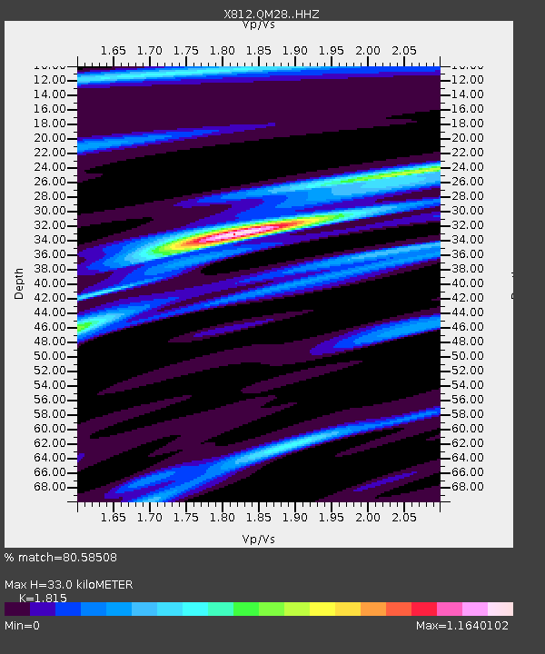
| Estimated Moho Depth: |
33.0 km |
| Estimated Crust Vp/Vs: |
1.82 |
| Assumed Crust Vp: |
6.419 km/s |
| Estimated Crust Vs: |
3.537 km/s |
| Estimated Crust Poisson's Ratio: |
0.28 |
|
| Radial Match: |
80.58508 % |
| Radial Bump: |
273 |
| Transverse Match: |
64.05814 % |
| Transverse Bump: |
400 |
| SOD ConfigId: |
3390531 |
| Insert Time: |
2019-04-10 09:14:14.181 +0000 |
| GWidth: |
2.5 |
| Max Bumps: |
400 |
| Tol: |
0.001 |
|

Signal To Noise
| Channel | StoN | STA | LTA |
| X8:QM28: :HHZ:20140218T09:33:16.284998Z | 3.2863722 | 3.3568115E-6 | 1.0214338E-6 |
| X8:QM28: :HHN:20140218T09:33:16.284998Z | 4.449841 | 1.9258061E-6 | 4.3278087E-7 |
| X8:QM28: :HHE:20140218T09:33:16.284998Z | 1.3116666 | 6.36244E-7 | 4.8506536E-7 |
| Arrivals |
| Ps | 4.5 SECOND |
| PpPs | 13 SECOND |
| PsPs/PpSs | 18 SECOND |


