You are here: Home > Network List > X812 - Deep Structure of Three Continental Sutures in Eastern North America Stations List
> Station QM66 Explorers Mine, Chibougamau, Quebec, Canada > Earthquake Result Viewer
QM66 Explorers Mine, Chibougamau, Quebec, Canada - Earthquake Result Viewer
| Earthquake location: |
North Atlantic Ocean |
| Earthquake latitude/longitude: |
14.7/-58.9 |
| Earthquake time(UTC): |
2014/02/18 (049) 09:27:13 GMT |
| Earthquake Depth: |
17 km |
| Earthquake Magnitude: |
6.5 MWW, 6.3 MWB, 6.5 MWC, 6.6 MWC, 6.7 MI |
| Earthquake Catalog/Contributor: |
NEIC PDE/NEIC COMCAT |
|
| Network: |
X8 Deep Structure of Three Continental Sutures in Eastern North America |
| Station: |
QM66 Explorers Mine, Chibougamau, Quebec, Canada |
| Lat/Lon: |
49.49 N/74.44 W |
| Elevation: |
405 m |
|
| Distance: |
37.0 deg |
| Az: |
343.154 deg |
| Baz: |
154.525 deg |
| Ray Param: |
0.0763646 |
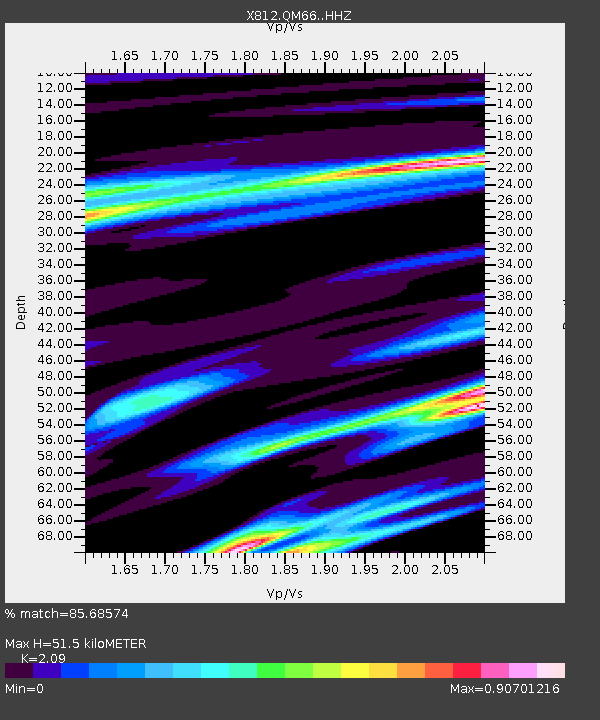
| Estimated Moho Depth: |
51.5 km |
| Estimated Crust Vp/Vs: |
2.09 |
| Assumed Crust Vp: |
6.61 km/s |
| Estimated Crust Vs: |
3.163 km/s |
| Estimated Crust Poisson's Ratio: |
0.35 |
|
| Radial Match: |
85.68574 % |
| Radial Bump: |
400 |
| Transverse Match: |
60.180565 % |
| Transverse Bump: |
400 |
| SOD ConfigId: |
3390531 |
| Insert Time: |
2019-04-10 09:14:20.452 +0000 |
| GWidth: |
2.5 |
| Max Bumps: |
400 |
| Tol: |
0.001 |
|

Signal To Noise
| Channel | StoN | STA | LTA |
| X8:QM66: :HHZ:20140218T09:33:51.520013Z | 4.073665 | 2.971255E-6 | 7.293812E-7 |
| X8:QM66: :HHN:20140218T09:33:51.520013Z | 3.2993655 | 1.4085774E-6 | 4.2692372E-7 |
| X8:QM66: :HHE:20140218T09:33:51.520013Z | 2.6827872 | 1.3759058E-6 | 5.128643E-7 |
| Arrivals |
| Ps | 9.1 SECOND |
| PpPs | 23 SECOND |
| PsPs/PpSs | 32 SECOND |


