You are here: Home > Network List > TA - USArray Transportable Network (new EarthScope stations) Stations List
> Station MDND Maddock, ND, USA > Earthquake Result Viewer
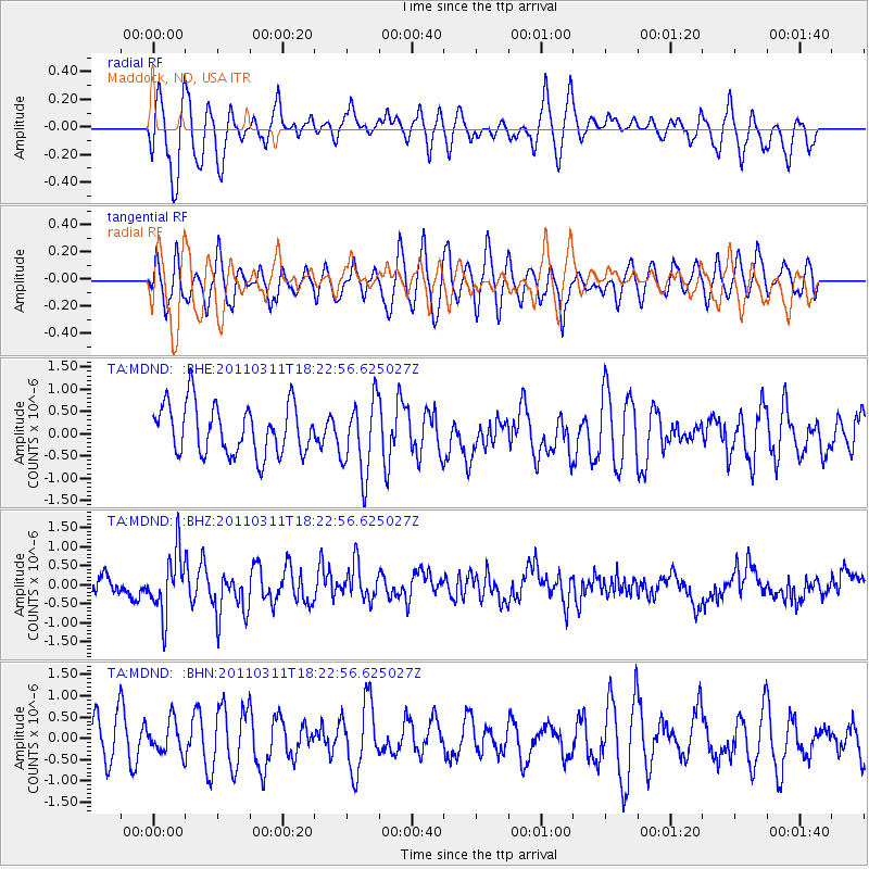
MDND Maddock, ND, USA - Earthquake Result Viewer
*The percent match for this event was below the threshold and hence no stack was calculated.
| Earthquake location: |
Off East Coast Of Honshu, Japan |
| Earthquake latitude/longitude: |
37.2/142.1 |
| Earthquake time(UTC): |
2011/03/11 (070) 18:11:24 GMT |
| Earthquake Depth: |
16 km |
| Earthquake Magnitude: |
5.7 MB |
| Earthquake Catalog/Contributor: |
WHDF/NEIC |
|
| Network: |
TA USArray Transportable Network (new EarthScope stations) |
| Station: |
MDND Maddock, ND, USA |
| Lat/Lon: |
47.85 N/99.60 W |
| Elevation: |
479 m |
|
| Distance: |
79.1 deg |
| Az: |
37.161 deg |
| Baz: |
314.267 deg |
| Ray Param: |
$rayparam |
*The percent match for this event was below the threshold and hence was not used in the summary stack. |
|
| Radial Match: |
68.93091 % |
| Radial Bump: |
400 |
| Transverse Match: |
61.0828 % |
| Transverse Bump: |
400 |
| SOD ConfigId: |
356183 |
| Insert Time: |
2011-08-17 19:00:26.524 +0000 |
| GWidth: |
2.5 |
| Max Bumps: |
400 |
| Tol: |
0.001 |
|
Signal To Noise
| Channel | StoN | STA | LTA |
| TA:MDND: :BHZ:20110311T18:22:56.625027Z | 2.9112236 | 8.106453E-7 | 2.784552E-7 |
| TA:MDND: :BHN:20110311T18:22:56.625027Z | 0.73386055 | 3.7382034E-7 | 5.0938877E-7 |
| TA:MDND: :BHE:20110311T18:22:56.625027Z | 1.4916737 | 8.398712E-7 | 5.6303946E-7 |
| Arrivals |
| Ps | |
| PpPs | |
| PsPs/PpSs | |


