You are here: Home > Network List > X812 - Deep Structure of Three Continental Sutures in Eastern North America Stations List
> Station QM80 Route du Nord, Quebec, Canada > Earthquake Result Viewer
QM80 Route du Nord, Quebec, Canada - Earthquake Result Viewer
| Earthquake location: |
North Atlantic Ocean |
| Earthquake latitude/longitude: |
14.7/-58.9 |
| Earthquake time(UTC): |
2014/02/18 (049) 09:27:13 GMT |
| Earthquake Depth: |
17 km |
| Earthquake Magnitude: |
6.5 MWW, 6.3 MWB, 6.5 MWC, 6.6 MWC, 6.7 MI |
| Earthquake Catalog/Contributor: |
NEIC PDE/NEIC COMCAT |
|
| Network: |
X8 Deep Structure of Three Continental Sutures in Eastern North America |
| Station: |
QM80 Route du Nord, Quebec, Canada |
| Lat/Lon: |
50.96 N/75.23 W |
| Elevation: |
371 m |
|
| Distance: |
38.5 deg |
| Az: |
343.454 deg |
| Baz: |
154.157 deg |
| Ray Param: |
0.07548553 |
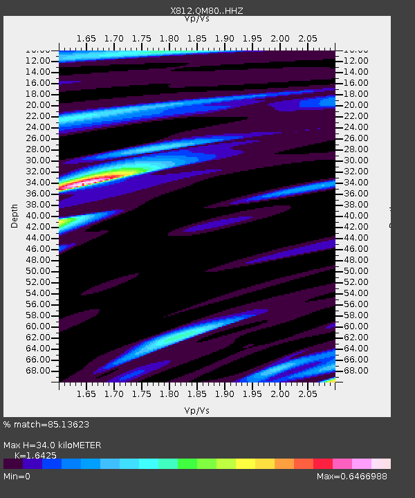
| Estimated Moho Depth: |
34.0 km |
| Estimated Crust Vp/Vs: |
1.64 |
| Assumed Crust Vp: |
6.61 km/s |
| Estimated Crust Vs: |
4.024 km/s |
| Estimated Crust Poisson's Ratio: |
0.21 |
|
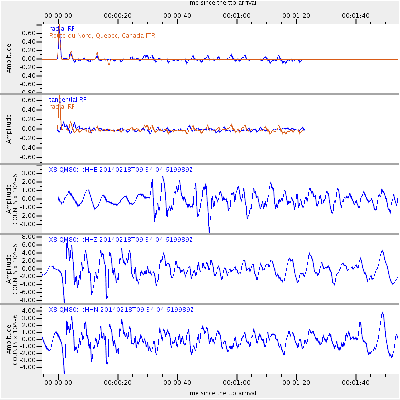
| Radial Match: |
85.13623 % |
| Radial Bump: |
254 |
| Transverse Match: |
62.63463 % |
| Transverse Bump: |
391 |
| SOD ConfigId: |
3390531 |
| Insert Time: |
2019-04-10 09:14:22.477 +0000 |
| GWidth: |
2.5 |
| Max Bumps: |
400 |
| Tol: |
0.001 |
|
Signal To Noise
| Channel | StoN | STA | LTA |
| X8:QM80: :HHZ:20140218T09:34:04.619989Z | 5.090795 | 3.9615743E-6 | 7.7818385E-7 |
| X8:QM80: :HHN:20140218T09:34:04.619989Z | 3.701689 | 1.9858676E-6 | 5.364761E-7 |
| X8:QM80: :HHE:20140218T09:34:04.619989Z | 2.1292858 | 1.1034517E-6 | 5.182263E-7 |
| Arrivals |
| Ps | 3.6 SECOND |
| PpPs | 13 SECOND |
| PsPs/PpSs | 16 SECOND |


