You are here: Home > Network List > TA - USArray Transportable Network (new EarthScope stations) Stations List
> Station T29A Hugoton, KS, USA > Earthquake Result Viewer
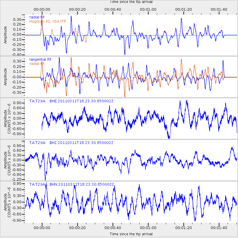
T29A Hugoton, KS, USA - Earthquake Result Viewer
*The percent match for this event was below the threshold and hence no stack was calculated.
| Earthquake location: |
Off East Coast Of Honshu, Japan |
| Earthquake latitude/longitude: |
37.2/142.1 |
| Earthquake time(UTC): |
2011/03/11 (070) 18:11:24 GMT |
| Earthquake Depth: |
16 km |
| Earthquake Magnitude: |
5.7 MB |
| Earthquake Catalog/Contributor: |
WHDF/NEIC |
|
| Network: |
TA USArray Transportable Network (new EarthScope stations) |
| Station: |
T29A Hugoton, KS, USA |
| Lat/Lon: |
37.16 N/101.29 W |
| Elevation: |
936 m |
|
| Distance: |
85.6 deg |
| Az: |
45.758 deg |
| Baz: |
314.273 deg |
| Ray Param: |
$rayparam |
*The percent match for this event was below the threshold and hence was not used in the summary stack. |
|
| Radial Match: |
55.277294 % |
| Radial Bump: |
386 |
| Transverse Match: |
39.74515 % |
| Transverse Bump: |
298 |
| SOD ConfigId: |
356183 |
| Insert Time: |
2011-08-17 19:01:26.143 +0000 |
| GWidth: |
2.5 |
| Max Bumps: |
400 |
| Tol: |
0.001 |
|
Signal To Noise
| Channel | StoN | STA | LTA |
| TA:T29A: :BHZ:20110311T18:23:30.850002Z | 2.4992907 | 5.0444504E-7 | 2.0183526E-7 |
| TA:T29A: :BHN:20110311T18:23:30.850002Z | 1.8072443 | 4.29714E-7 | 2.3777305E-7 |
| TA:T29A: :BHE:20110311T18:23:30.850002Z | 0.64183664 | 1.7231258E-7 | 2.6846797E-7 |
| Arrivals |
| Ps | |
| PpPs | |
| PsPs/PpSs | |


