You are here: Home > Network List > TA - USArray Transportable Network (new EarthScope stations) Stations List
> Station H28A Mission Ridge, SD, USA > Earthquake Result Viewer
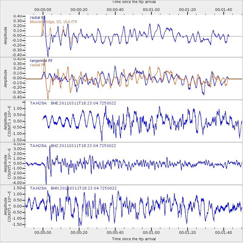
H28A Mission Ridge, SD, USA - Earthquake Result Viewer
*The percent match for this event was below the threshold and hence no stack was calculated.
| Earthquake location: |
Off East Coast Of Honshu, Japan |
| Earthquake latitude/longitude: |
37.2/142.1 |
| Earthquake time(UTC): |
2011/03/11 (070) 18:11:24 GMT |
| Earthquake Depth: |
16 km |
| Earthquake Magnitude: |
5.7 MB |
| Earthquake Catalog/Contributor: |
WHDF/NEIC |
|
| Network: |
TA USArray Transportable Network (new EarthScope stations) |
| Station: |
H28A Mission Ridge, SD, USA |
| Lat/Lon: |
44.68 N/101.02 W |
| Elevation: |
642 m |
|
| Distance: |
80.5 deg |
| Az: |
40.174 deg |
| Baz: |
313.779 deg |
| Ray Param: |
$rayparam |
*The percent match for this event was below the threshold and hence was not used in the summary stack. |
|
| Radial Match: |
59.966724 % |
| Radial Bump: |
400 |
| Transverse Match: |
51.520546 % |
| Transverse Bump: |
393 |
| SOD ConfigId: |
356183 |
| Insert Time: |
2011-08-17 19:07:49.293 +0000 |
| GWidth: |
2.5 |
| Max Bumps: |
400 |
| Tol: |
0.001 |
|
Signal To Noise
| Channel | StoN | STA | LTA |
| TA:H28A: :BHZ:20110311T18:23:04.725002Z | 8.420508 | 1.5617836E-6 | 1.8547378E-7 |
| TA:H28A: :BHN:20110311T18:23:04.725002Z | 1.2823309 | 6.3737167E-7 | 4.970415E-7 |
| TA:H28A: :BHE:20110311T18:23:04.725002Z | 1.8499397 | 6.4021606E-7 | 3.4607402E-7 |
| Arrivals |
| Ps | |
| PpPs | |
| PsPs/PpSs | |


