You are here: Home > Network List > TA - USArray Transportable Network (new EarthScope stations) Stations List
> Station W34A Bridge Creek, Tuttle, OK, USA > Earthquake Result Viewer
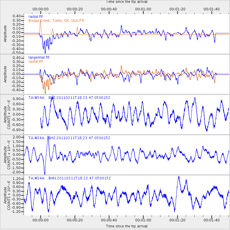
W34A Bridge Creek, Tuttle, OK, USA - Earthquake Result Viewer
*The percent match for this event was below the threshold and hence no stack was calculated.
| Earthquake location: |
Off East Coast Of Honshu, Japan |
| Earthquake latitude/longitude: |
37.2/142.1 |
| Earthquake time(UTC): |
2011/03/11 (070) 18:11:24 GMT |
| Earthquake Depth: |
16 km |
| Earthquake Magnitude: |
5.7 MB |
| Earthquake Catalog/Contributor: |
WHDF/NEIC |
|
| Network: |
TA USArray Transportable Network (new EarthScope stations) |
| Station: |
W34A Bridge Creek, Tuttle, OK, USA |
| Lat/Lon: |
35.24 N/97.77 W |
| Elevation: |
428 m |
|
| Distance: |
89.0 deg |
| Az: |
45.082 deg |
| Baz: |
316.312 deg |
| Ray Param: |
$rayparam |
*The percent match for this event was below the threshold and hence was not used in the summary stack. |
|
| Radial Match: |
61.133945 % |
| Radial Bump: |
400 |
| Transverse Match: |
45.117508 % |
| Transverse Bump: |
331 |
| SOD ConfigId: |
356183 |
| Insert Time: |
2011-08-17 19:22:40.482 +0000 |
| GWidth: |
2.5 |
| Max Bumps: |
400 |
| Tol: |
0.001 |
|
Signal To Noise
| Channel | StoN | STA | LTA |
| TA:W34A: :BHZ:20110311T18:23:47.050015Z | 2.7151122 | 1.124821E-6 | 4.142816E-7 |
| TA:W34A: :BHN:20110311T18:23:47.050015Z | 1.1832662 | 5.2210305E-7 | 4.412389E-7 |
| TA:W34A: :BHE:20110311T18:23:47.050015Z | 0.6398915 | 2.9610774E-7 | 4.6274678E-7 |
| Arrivals |
| Ps | |
| PpPs | |
| PsPs/PpSs | |


