You are here: Home > Network List > XK12 - Seismic Arrays for African Rift Initation Stations List
> Station Z01TG Katonga Basic School, Zambia > Earthquake Result Viewer
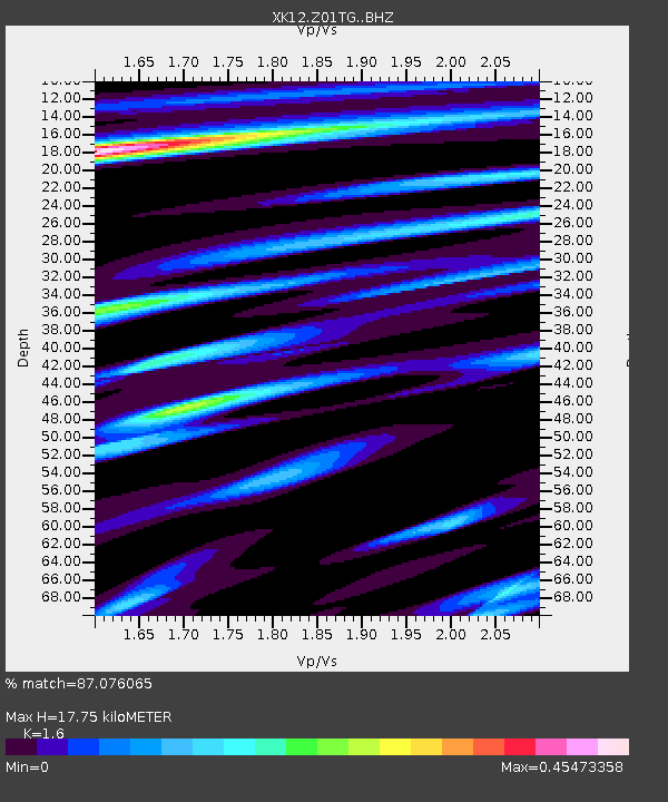
Z01TG Katonga Basic School, Zambia - Earthquake Result Viewer
| Earthquake location: |
North Atlantic Ocean |
| Earthquake latitude/longitude: |
14.7/-58.9 |
| Earthquake time(UTC): |
2014/02/18 (049) 09:27:13 GMT |
| Earthquake Depth: |
17 km |
| Earthquake Magnitude: |
6.5 MWW, 6.3 MWB, 6.5 MWC, 6.6 MWC, 6.7 MI |
| Earthquake Catalog/Contributor: |
NEIC PDE/NEIC COMCAT |
|
| Network: |
XK Seismic Arrays for African Rift Initation |
| Station: |
Z01TG Katonga Basic School, Zambia |
| Lat/Lon: |
12.30 S/29.99 E |
| Elevation: |
1170 m |
|
| Distance: |
92.0 deg |
| Az: |
102.096 deg |
| Baz: |
284.457 deg |
| Ray Param: |
0.041517727 |
| Estimated Moho Depth: |
17.75 km |
| Estimated Crust Vp/Vs: |
1.60 |
| Assumed Crust Vp: |
6.642 km/s |
| Estimated Crust Vs: |
4.151 km/s |
| Estimated Crust Poisson's Ratio: |
0.18 |
|
| Radial Match: |
87.076065 % |
| Radial Bump: |
400 |
| Transverse Match: |
76.92005 % |
| Transverse Bump: |
400 |
| SOD ConfigId: |
3390531 |
| Insert Time: |
2019-04-10 09:14:55.222 +0000 |
| GWidth: |
2.5 |
| Max Bumps: |
400 |
| Tol: |
0.001 |
|

Signal To Noise
| Channel | StoN | STA | LTA |
| XK:Z01TG: :BHZ:20140218T09:39:49.759973Z | 3.7523432 | 5.284688E-7 | 1.40837E-7 |
| XK:Z01TG: :BHN:20140218T09:39:49.759973Z | 0.8441815 | 1.2278645E-7 | 1.4545029E-7 |
| XK:Z01TG: :BHE:20140218T09:39:49.759973Z | 0.91508585 | 1.9141653E-7 | 2.0917876E-7 |
| Arrivals |
| Ps | 1.6 SECOND |
| PpPs | 6.8 SECOND |
| PsPs/PpSs | 8.4 SECOND |


