You are here: Home > Network List > TA - USArray Transportable Network (new EarthScope stations) Stations List
> Station Q34A Chapman, KS, USA > Earthquake Result Viewer
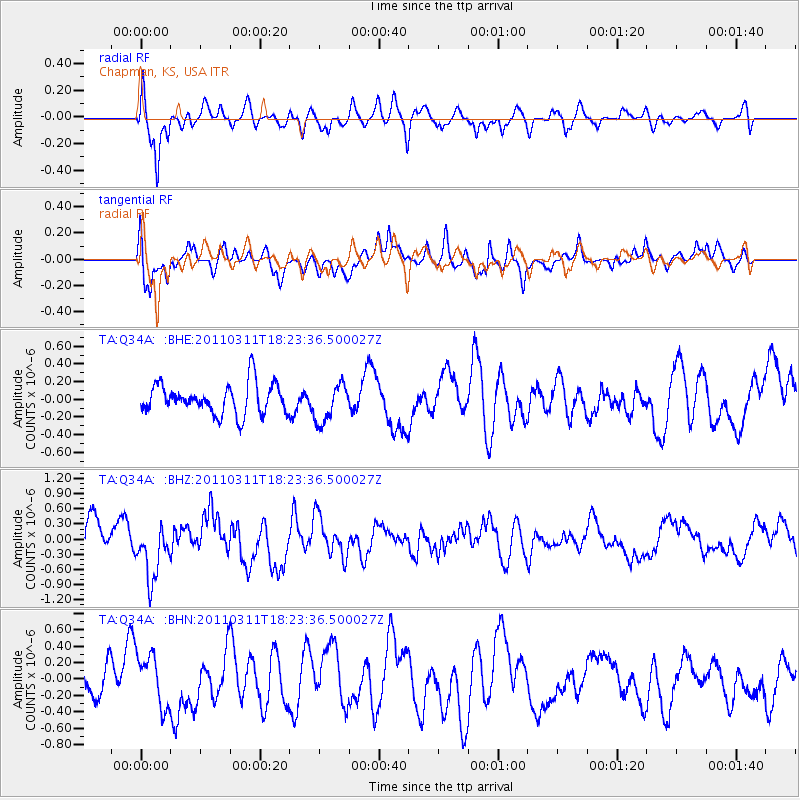
Q34A Chapman, KS, USA - Earthquake Result Viewer
*The percent match for this event was below the threshold and hence no stack was calculated.
| Earthquake location: |
Off East Coast Of Honshu, Japan |
| Earthquake latitude/longitude: |
37.2/142.1 |
| Earthquake time(UTC): |
2011/03/11 (070) 18:11:24 GMT |
| Earthquake Depth: |
16 km |
| Earthquake Magnitude: |
5.7 MB |
| Earthquake Catalog/Contributor: |
WHDF/NEIC |
|
| Network: |
TA USArray Transportable Network (new EarthScope stations) |
| Station: |
Q34A Chapman, KS, USA |
| Lat/Lon: |
38.92 N/96.94 W |
| Elevation: |
378 m |
|
| Distance: |
86.8 deg |
| Az: |
42.064 deg |
| Baz: |
316.701 deg |
| Ray Param: |
$rayparam |
*The percent match for this event was below the threshold and hence was not used in the summary stack. |
|
| Radial Match: |
66.15686 % |
| Radial Bump: |
400 |
| Transverse Match: |
71.14481 % |
| Transverse Bump: |
400 |
| SOD ConfigId: |
356183 |
| Insert Time: |
2011-08-17 19:29:05.862 +0000 |
| GWidth: |
2.5 |
| Max Bumps: |
400 |
| Tol: |
0.001 |
|
Signal To Noise
| Channel | StoN | STA | LTA |
| TA:Q34A: :BHZ:20110311T18:23:36.500027Z | 2.1758475 | 5.6394083E-7 | 2.5918214E-7 |
| TA:Q34A: :BHN:20110311T18:23:36.500027Z | 1.5502453 | 3.2120127E-7 | 2.0719384E-7 |
| TA:Q34A: :BHE:20110311T18:23:36.500027Z | 1.2479696 | 2.1360017E-7 | 1.7115816E-7 |
| Arrivals |
| Ps | |
| PpPs | |
| PsPs/PpSs | |


