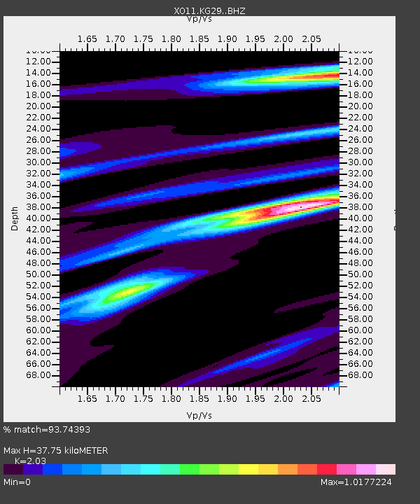
KG29 KG29 of OIINK Flexarray - Earthquake Result Viewer

Earthquake location: North Atlantic Ocean
Earthquake latitude/longitude: 14.7/-58.9
Earthquake time(UTC): 2014/02/18 (049) 09:27:13 GMT
Earthquake Depth: 17 km
Earthquake Magnitude: 6.5 MWW, 6.3 MWB, 6.5 MWC, 6.6 MWC, 6.7 MI
Earthquake Catalog/Contributor: NEIC PDE/NEIC COMCAT
Network: XO Ozark Illinois, Indiana and Kentucky ES Flexible Array
Station: KG29 KG29 of OIINK Flexarray
Lat/Lon: 37.72 N/87.47 W
Elevation: 129 m
Distance: 34.2 deg
Az: 317.572 deg
Baz: 124.568 deg
Ray Param: 0.07785681
Estimated Moho Depth: 37.75 km
Estimated Crust Vp/Vs: 2.03
Assumed Crust Vp: 6.444 km/s
Estimated Crust Vs: 3.174 km/s
Estimated Crust Poisson's Ratio: 0.34
Radial Match: 93.74393 %
Radial Bump: 253
Transverse Match: 76.5658 %
Transverse Bump: 400
SOD ConfigId: 3390531
Insert Time: 2019-04-10 09:15:01.904 +0000
GWidth: 2.5
Max Bumps: 400
Tol: 0.001

Signal To Noise

ChannelStoNSTALTA
XO:KG29: :BHZ:20140218T09:33:27.159998Z11.7840373.1259226E-62.6526754E-7
XO:KG29: :BHN:20140218T09:33:27.159998Z3.47190939.530932E-72.745156E-7
XO:KG29: :BHE:20140218T09:33:27.159998Z5.4312141.3770988E-62.5355268E-7
Arrivals
Ps6.5 SECOND
PpPs17 SECOND
PsPs/PpSs23 SECOND