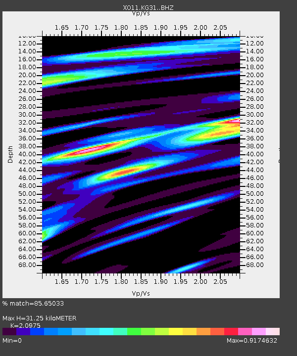
KG31 KG31 of OIINK Flexarray - Earthquake Result Viewer

Earthquake location: North Atlantic Ocean
Earthquake latitude/longitude: 14.7/-58.9
Earthquake time(UTC): 2014/02/18 (049) 09:27:13 GMT
Earthquake Depth: 17 km
Earthquake Magnitude: 6.5 MWW, 6.3 MWB, 6.5 MWC, 6.6 MWC, 6.7 MI
Earthquake Catalog/Contributor: NEIC PDE/NEIC COMCAT
Network: XO Ozark Illinois, Indiana and Kentucky ES Flexible Array
Station: KG31 KG31 of OIINK Flexarray
Lat/Lon: 37.65 N/87.18 W
Elevation: 129 m
Distance: 33.9 deg
Az: 317.712 deg
Baz: 124.862 deg
Ray Param: 0.07796149
Estimated Moho Depth: 31.25 km
Estimated Crust Vp/Vs: 2.10
Assumed Crust Vp: 6.444 km/s
Estimated Crust Vs: 3.072 km/s
Estimated Crust Poisson's Ratio: 0.35
Radial Match: 85.65033 %
Radial Bump: 400
Transverse Match: 75.080605 %
Transverse Bump: 400
SOD ConfigId: 3390531
Insert Time: 2019-04-10 09:15:02.857 +0000
GWidth: 2.5
Max Bumps: 400
Tol: 0.001

Signal To Noise

ChannelStoNSTALTA
XO:KG31: :BHZ:20140218T09:33:25.195001Z11.402351.9916881E-61.7467347E-7
XO:KG31: :BHN:20140218T09:33:25.195001Z2.15976381.0116231E-64.6839526E-7
XO:KG31: :BHE:20140218T09:33:25.195001Z2.29305849.2883977E-74.0506592E-7
Arrivals
Ps5.7 SECOND
PpPs14 SECOND
PsPs/PpSs20 SECOND