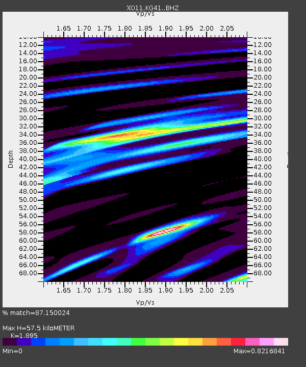
KG41 KG41 of OIINK Flexarray - Earthquake Result Viewer

Earthquake location: North Atlantic Ocean
Earthquake latitude/longitude: 14.7/-58.9
Earthquake time(UTC): 2014/02/18 (049) 09:27:13 GMT
Earthquake Depth: 17 km
Earthquake Magnitude: 6.5 MWW, 6.3 MWB, 6.5 MWC, 6.6 MWC, 6.7 MI
Earthquake Catalog/Contributor: NEIC PDE/NEIC COMCAT
Network: XO Ozark Illinois, Indiana and Kentucky ES Flexible Array
Station: KG41 KG41 of OIINK Flexarray
Lat/Lon: 37.67 N/85.74 W
Elevation: 274 m
Distance: 33.0 deg
Az: 318.942 deg
Baz: 126.763 deg
Ray Param: 0.07838472
Estimated Moho Depth: 57.5 km
Estimated Crust Vp/Vs: 1.89
Assumed Crust Vp: 6.476 km/s
Estimated Crust Vs: 3.417 km/s
Estimated Crust Poisson's Ratio: 0.31
Radial Match: 87.150024 %
Radial Bump: 397
Transverse Match: 57.978073 %
Transverse Bump: 400
SOD ConfigId: 3390531
Insert Time: 2019-04-10 09:15:06.647 +0000
GWidth: 2.5
Max Bumps: 400
Tol: 0.001

Signal To Noise

ChannelStoNSTALTA
XO:KG41: :BHZ:20140218T09:33:17.240015Z5.9021181.6612759E-62.8147113E-7
XO:KG41: :BHN:20140218T09:33:17.240015Z0.879943855.73508E-76.517552E-7
XO:KG41: :BHE:20140218T09:33:17.240015Z1.74497716.8602884E-73.9314492E-7
Arrivals
Ps8.6 SECOND
PpPs24 SECOND
PsPs/PpSs32 SECOND