You are here: Home > Network List > TA - USArray Transportable Network (new EarthScope stations) Stations List
> Station A33A Warroad, MN, USA > Earthquake Result Viewer
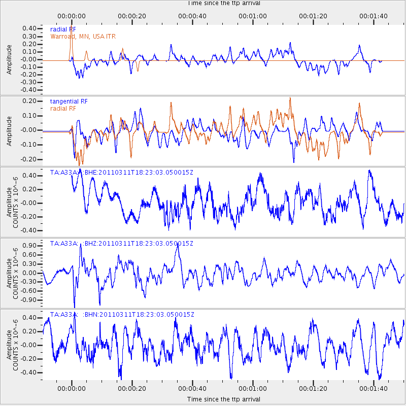
A33A Warroad, MN, USA - Earthquake Result Viewer
*The percent match for this event was below the threshold and hence no stack was calculated.
| Earthquake location: |
Off East Coast Of Honshu, Japan |
| Earthquake latitude/longitude: |
37.2/142.1 |
| Earthquake time(UTC): |
2011/03/11 (070) 18:11:24 GMT |
| Earthquake Depth: |
16 km |
| Earthquake Magnitude: |
5.7 MB |
| Earthquake Catalog/Contributor: |
WHDF/NEIC |
|
| Network: |
TA USArray Transportable Network (new EarthScope stations) |
| Station: |
A33A Warroad, MN, USA |
| Lat/Lon: |
48.94 N/95.39 W |
| Elevation: |
329 m |
|
| Distance: |
80.2 deg |
| Az: |
34.348 deg |
| Baz: |
316.902 deg |
| Ray Param: |
$rayparam |
*The percent match for this event was below the threshold and hence was not used in the summary stack. |
|
| Radial Match: |
66.23147 % |
| Radial Bump: |
355 |
| Transverse Match: |
53.415573 % |
| Transverse Bump: |
365 |
| SOD ConfigId: |
356183 |
| Insert Time: |
2011-08-17 19:43:08.501 +0000 |
| GWidth: |
2.5 |
| Max Bumps: |
400 |
| Tol: |
0.001 |
|
Signal To Noise
| Channel | StoN | STA | LTA |
| TA:A33A: :BHZ:20110311T18:23:03.050015Z | 2.3070972 | 4.7691753E-7 | 2.0671756E-7 |
| TA:A33A: :BHN:20110311T18:23:03.050015Z | 1.0223378 | 2.1470065E-7 | 2.100095E-7 |
| TA:A33A: :BHE:20110311T18:23:03.050015Z | 1.152373 | 2.3767579E-7 | 2.0624901E-7 |
| Arrivals |
| Ps | |
| PpPs | |
| PsPs/PpSs | |


