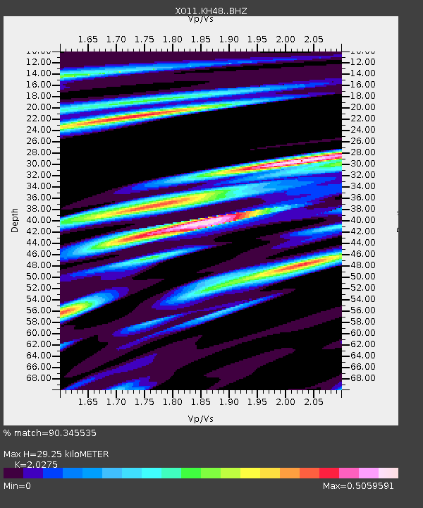
KH48 KH48 of OIINK Flexarray - Earthquake Result Viewer

Earthquake location: North Atlantic Ocean
Earthquake latitude/longitude: 14.7/-58.9
Earthquake time(UTC): 2014/02/18 (049) 09:27:13 GMT
Earthquake Depth: 17 km
Earthquake Magnitude: 6.5 MWW, 6.3 MWB, 6.5 MWC, 6.6 MWC, 6.7 MI
Earthquake Catalog/Contributor: NEIC PDE/NEIC COMCAT
Network: XO Ozark Illinois, Indiana and Kentucky ES Flexible Array
Station: KH48 KH48 of OIINK Flexarray
Lat/Lon: 37.45 N/85.01 W
Elevation: 254 m
Distance: 32.4 deg
Az: 319.271 deg
Baz: 127.488 deg
Ray Param: 0.07864461
Estimated Moho Depth: 29.25 km
Estimated Crust Vp/Vs: 2.03
Assumed Crust Vp: 6.476 km/s
Estimated Crust Vs: 3.194 km/s
Estimated Crust Poisson's Ratio: 0.34
Radial Match: 90.345535 %
Radial Bump: 337
Transverse Match: 88.21811 %
Transverse Bump: 400
SOD ConfigId: 3390531
Insert Time: 2019-04-10 09:15:15.088 +0000
GWidth: 2.5
Max Bumps: 400
Tol: 0.001

Signal To Noise

ChannelStoNSTALTA
XO:KH48: :BHZ:20140218T09:33:12.010004Z6.1363721.3931432E-62.2703044E-7
XO:KH48: :BHN:20140218T09:33:12.010004Z3.07043465.446078E-71.7737158E-7
XO:KH48: :BHE:20140218T09:33:12.010004Z3.8842726.799227E-71.7504507E-7
Arrivals
Ps5.0 SECOND
PpPs13 SECOND
PsPs/PpSs18 SECOND