You are here: Home > Network List > TA - USArray Transportable Network (new EarthScope stations) Stations List
> Station K36A Gilmore City, IA, USA > Earthquake Result Viewer
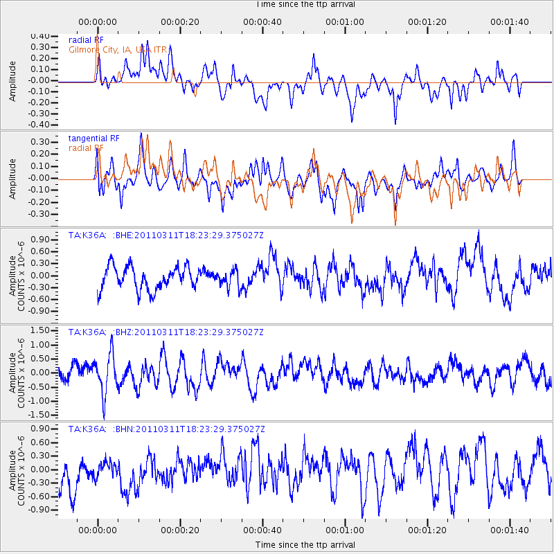
K36A Gilmore City, IA, USA - Earthquake Result Viewer
*The percent match for this event was below the threshold and hence no stack was calculated.
| Earthquake location: |
Off East Coast Of Honshu, Japan |
| Earthquake latitude/longitude: |
37.2/142.1 |
| Earthquake time(UTC): |
2011/03/11 (070) 18:11:24 GMT |
| Earthquake Depth: |
16 km |
| Earthquake Magnitude: |
5.7 MB |
| Earthquake Catalog/Contributor: |
WHDF/NEIC |
|
| Network: |
TA USArray Transportable Network (new EarthScope stations) |
| Station: |
K36A Gilmore City, IA, USA |
| Lat/Lon: |
42.64 N/94.45 W |
| Elevation: |
364 m |
|
| Distance: |
85.3 deg |
| Az: |
38.15 deg |
| Baz: |
318.053 deg |
| Ray Param: |
$rayparam |
*The percent match for this event was below the threshold and hence was not used in the summary stack. |
|
| Radial Match: |
63.625046 % |
| Radial Bump: |
400 |
| Transverse Match: |
60.18673 % |
| Transverse Bump: |
400 |
| SOD ConfigId: |
356183 |
| Insert Time: |
2011-08-17 19:44:50.671 +0000 |
| GWidth: |
2.5 |
| Max Bumps: |
400 |
| Tol: |
0.001 |
|
Signal To Noise
| Channel | StoN | STA | LTA |
| TA:K36A: :BHZ:20110311T18:23:29.375027Z | 2.415524 | 7.0956673E-7 | 2.9375272E-7 |
| TA:K36A: :BHN:20110311T18:23:29.375027Z | 0.38627383 | 2.0545819E-7 | 5.318978E-7 |
| TA:K36A: :BHE:20110311T18:23:29.375027Z | 0.7557659 | 2.1823298E-7 | 2.8875738E-7 |
| Arrivals |
| Ps | |
| PpPs | |
| PsPs/PpSs | |


