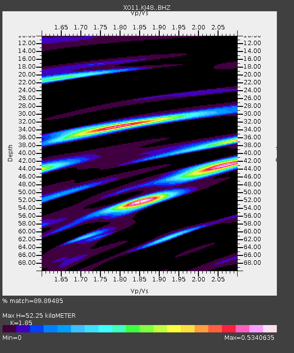
KJ48 KJ48 of OIINK Flexarray - Earthquake Result Viewer

Earthquake location: North Atlantic Ocean
Earthquake latitude/longitude: 14.7/-58.9
Earthquake time(UTC): 2014/02/18 (049) 09:27:13 GMT
Earthquake Depth: 17 km
Earthquake Magnitude: 6.5 MWW, 6.3 MWB, 6.5 MWC, 6.6 MWC, 6.7 MI
Earthquake Catalog/Contributor: NEIC PDE/NEIC COMCAT
Network: XO Ozark Illinois, Indiana and Kentucky ES Flexible Array
Station: KJ48 KJ48 of OIINK Flexarray
Lat/Lon: 37.05 N/85.05 W
Elevation: 316 m
Distance: 32.2 deg
Az: 318.645 deg
Baz: 126.933 deg
Ray Param: 0.07873476
Estimated Moho Depth: 52.25 km
Estimated Crust Vp/Vs: 1.85
Assumed Crust Vp: 6.476 km/s
Estimated Crust Vs: 3.5 km/s
Estimated Crust Poisson's Ratio: 0.29
Radial Match: 89.89485 %
Radial Bump: 271
Transverse Match: 69.40599 %
Transverse Bump: 400
SOD ConfigId: 3390531
Insert Time: 2019-04-10 09:15:27.139 +0000
GWidth: 2.5
Max Bumps: 400
Tol: 0.001

Signal To Noise

ChannelStoNSTALTA
XO:KJ48: :BHZ:20140218T09:33:10.140009Z5.94570451.6081241E-62.704682E-7
XO:KJ48: :BHN:20140218T09:33:10.140009Z3.55549485.4086934E-71.521221E-7
XO:KJ48: :BHE:20140218T09:33:10.140009Z2.5214126.2243197E-72.468585E-7
Arrivals
Ps7.4 SECOND
PpPs21 SECOND
PsPs/PpSs29 SECOND