You are here: Home > Network List > UW - Pacific Northwest Regional Seismic Network Stations List
> Station LEBA Lebam, WA, USA > Earthquake Result Viewer
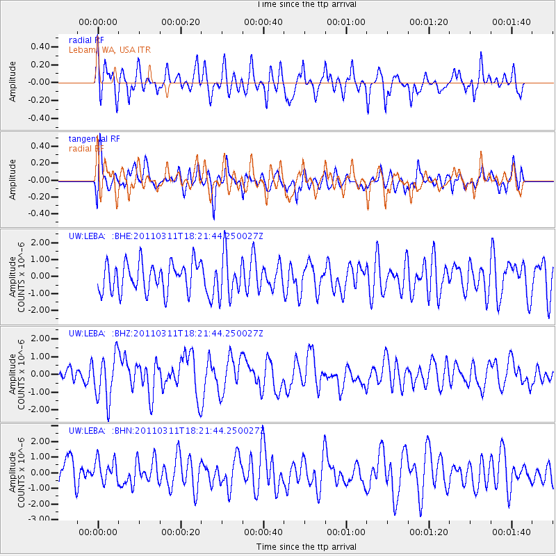
LEBA Lebam, WA, USA - Earthquake Result Viewer
*The percent match for this event was below the threshold and hence no stack was calculated.
| Earthquake location: |
Off East Coast Of Honshu, Japan |
| Earthquake latitude/longitude: |
37.2/142.1 |
| Earthquake time(UTC): |
2011/03/11 (070) 18:11:24 GMT |
| Earthquake Depth: |
16 km |
| Earthquake Magnitude: |
5.7 MB |
| Earthquake Catalog/Contributor: |
WHDF/NEIC |
|
| Network: |
UW Pacific Northwest Regional Seismic Network |
| Station: |
LEBA Lebam, WA, USA |
| Lat/Lon: |
46.55 N/123.56 W |
| Elevation: |
73 m |
|
| Distance: |
66.8 deg |
| Az: |
48.483 deg |
| Baz: |
299.974 deg |
| Ray Param: |
$rayparam |
*The percent match for this event was below the threshold and hence was not used in the summary stack. |
|
| Radial Match: |
62.633682 % |
| Radial Bump: |
400 |
| Transverse Match: |
49.135067 % |
| Transverse Bump: |
400 |
| SOD ConfigId: |
356183 |
| Insert Time: |
2011-08-17 20:08:11.896 +0000 |
| GWidth: |
2.5 |
| Max Bumps: |
400 |
| Tol: |
0.001 |
|
Signal To Noise
| Channel | StoN | STA | LTA |
| UW:LEBA: :BHZ:20110311T18:21:44.250027Z | 2.9418852 | 1.3056618E-6 | 4.4381807E-7 |
| UW:LEBA: :BHN:20110311T18:21:44.250027Z | 0.80306935 | 7.481208E-7 | 9.3157684E-7 |
| UW:LEBA: :BHE:20110311T18:21:44.250027Z | 1.4955766 | 1.268456E-6 | 8.481384E-7 |
| Arrivals |
| Ps | |
| PpPs | |
| PsPs/PpSs | |


