You are here: Home > Network List > AR - Northern Arizona Network Stations List
> Station Y14A Wickenburg, AZ, USA > Earthquake Result Viewer
Y14A Wickenburg, AZ, USA - Earthquake Result Viewer
| Earthquake location: |
Near West Coast Of Honshu, Japan |
| Earthquake latitude/longitude: |
37.0/138.4 |
| Earthquake time(UTC): |
2011/03/11 (070) 18:59:16 GMT |
| Earthquake Depth: |
9.3 km |
| Earthquake Magnitude: |
6.1 MB, 6.1 MS, 6.3 MW, 6.2 MW |
| Earthquake Catalog/Contributor: |
WHDF/NEIC |
|
| Network: |
AR Northern Arizona Network |
| Station: |
Y14A Wickenburg, AZ, USA |
| Lat/Lon: |
33.94 N/113.00 W |
| Elevation: |
731 m |
|
| Distance: |
83.1 deg |
| Az: |
52.528 deg |
| Baz: |
310.172 deg |
| Ray Param: |
0.046449177 |
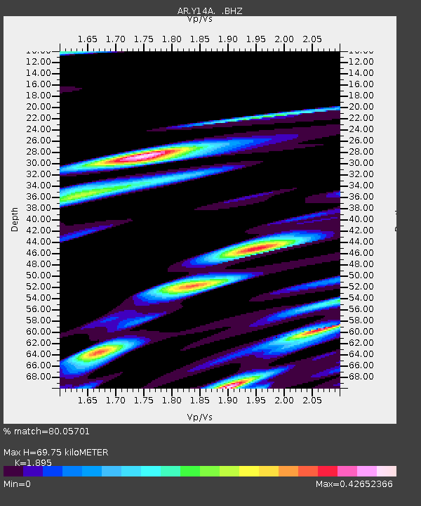
| Estimated Moho Depth: |
69.75 km |
| Estimated Crust Vp/Vs: |
1.89 |
| Assumed Crust Vp: |
6.264 km/s |
| Estimated Crust Vs: |
3.305 km/s |
| Estimated Crust Poisson's Ratio: |
0.31 |
|
| Radial Match: |
80.05701 % |
| Radial Bump: |
400 |
| Transverse Match: |
66.134384 % |
| Transverse Bump: |
400 |
| SOD ConfigId: |
356183 |
| Insert Time: |
2011-08-17 21:34:45.233 +0000 |
| GWidth: |
2.5 |
| Max Bumps: |
400 |
| Tol: |
0.001 |
|

Signal To Noise
| Channel | StoN | STA | LTA |
| AR:Y14A: :BHZ:20110311T19:11:10.849998Z | 1.5347534 | 2.3523876E-6 | 1.5327463E-6 |
| AR:Y14A: :BHN:20110311T19:11:10.849998Z | 2.3176775 | 1.1944452E-6 | 5.1536296E-7 |
| AR:Y14A: :BHE:20110311T19:11:10.849998Z | 0.4560635 | 4.7780856E-7 | 1.0476798E-6 |
| Arrivals |
| Ps | 10 SECOND |
| PpPs | 32 SECOND |
| PsPs/PpSs | 42 SECOND |


